Carranglan night lights from space
Night Light of Carranglan (Central Luzon) from space (Philippines) Src. Average luminocity for 10x10km area is 0% and for 50x50km: 0.4619%.
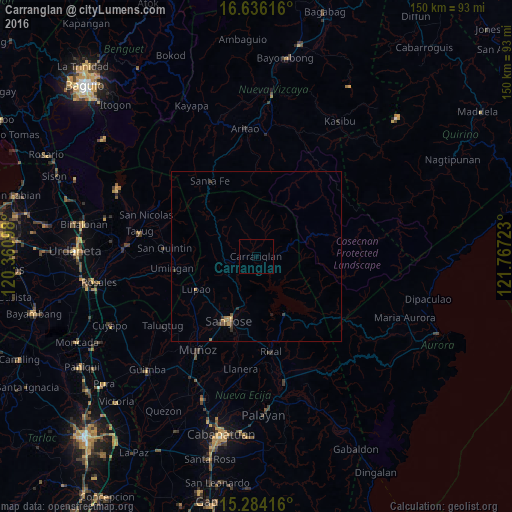
Analysis of Carranglan night lights 2016
Square area 10x10 km:
 0%
0%90-99
0%80-89
0%70-79
0%60-69
0%50-59
0%40-49
0%30-39
0%20-29
0%10-19
0%0-9
100%Square area 50x50 km:
0%90-99
0%80-89
0.02%70-79
0.14%60-69
0.1%50-59
0.08%40-49
0.12%30-39
0.2%20-29
0.06%10-19
0.06%0-9
99.21%Clear (daylight) street map image can be seen on geolist.org.
Map coordinates:
16° 38' 10.2" North, 120° 21' 39.5" East
15° 57' 40.7" North, 121° 3' 50.8" East
15° 17' 3" North, 121° 46' 2" East
Some cities around Carranglan sort by population:
• Muñoz
32.2 km =20 mi,  212°
212°
• Rizal
28.1 km =17.5 mi,  170°
170°
• Lupao
19.9 km =12.4 mi,  242°
242°
• Bone South
32.3 km =20.1 mi,  346°
346°
• Pantabangan
18.8 km =11.7 mi,  152°
152°
• Natividad
29.8 km =18.5 mi,  288°
288°
• Santo Tomas
25.9 km =16.1 mi,  204°
204°
• Llanera
33.5 km =20.8 mi,  188°
188°
1718266 (p: 11,017)
Sources (retrieved 2019-11-25):
» Earth at Night: Flat Maps 2012, 2016