Cabcaben night lights from space
Night Light of Cabcaben (Central Luzon) from space (Philippines) Src. Average luminocity for 10x10km area is 14.8485% and for 50x50km: 4.1422%.
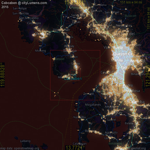
Analysis of Cabcaben night lights 2016
Square area 10x10 km:
 0%
0%90-99
0%80-89
0%70-79
2.6%60-69
1.73%50-59
5.84%40-49
1.95%30-39
2.81%20-29
4.76%10-19
25.97%0-9
54.33%Square area 50x50 km:
0.22%90-99
0.17%80-89
0.15%70-79
0.81%60-69
0.74%50-59
0.67%40-49
0.96%30-39
1.02%20-29
0.68%10-19
3.61%0-9
90.98%Clear (daylight) street map image can be seen on geolist.org.
Map coordinates:
15° 8' 1.7" North, 119° 53' 17.8" East
14° 27' 14.4" North, 120° 35' 29" East
13° 46' 19.6" North, 121° 17' 40.3" East
Some cities around Cabcaben sort by population:
• Mariveles
11.6 km =7.2 mi,  258°
258°
• Balanga
25.4 km =15.8 mi,  346°
346°
• Naic
24.1 km =15 mi,  128°
128°
• Limay
12 km =7.5 mi,  3°
3°
• Orion
18.5 km =11.5 mi,  356°
356°
• Ternate
22.7 km =14.1 mi,  143°
143°
• Pilar
23.1 km =14.4 mi, 353°
• Halayhay
25.5 km =15.8 mi,  110°
110°
1721658 (p: 5,949)
Sources (retrieved 2019-11-25):
» Earth at Night: Flat Maps 2012, 2016