Pilar night lights from space
Night Light of Pilar (Central Luzon) from space (Philippines) Src. Average luminocity for 10x10km area is 20.4978% and for 50x50km: 6.2435%.
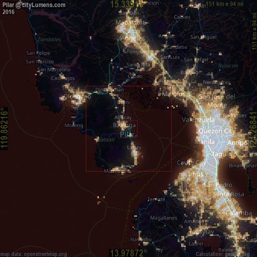
Analysis of Pilar night lights 2016
Square area 10x10 km:
 0.65%
0.65%90-99
1.08%80-89
2.6%70-79
4.98%60-69
6.49%50-59
2.38%40-49
4.33%30-39
3.68%20-29
1.08%10-19
10.82%0-9
61.9%Square area 50x50 km:
0.22%90-99
0.2%80-89
0.23%70-79
1.2%60-69
1.47%50-59
0.97%40-49
1.38%30-39
1.64%20-29
1.3%10-19
4.82%0-9
86.58%Clear (daylight) street map image can be seen on geolist.org.
Map coordinates:
15° 20' 21" North, 119° 51' 43.8" East
14° 39' 36" North, 120° 33' 55" East
13° 58' 43.4" North, 121° 16' 6.3" East
Some cities around Pilar sort by population:
• Balanga
3.6 km =2.2 mi,  299°
299°
• Limay
11.5 km =7.1 mi,  161°
161°
• Orion
4.7 km =2.9 mi, 158°
• Orani
15.9 km =9.9 mi,  349°
349°
• Abucay
8.9 km =5.5 mi,  337°
337°
• Hermosa
20 km =12.4 mi, 342°
• Samal
12.2 km =7.6 mi, 348°
• Cabcaben
23.1 km =14.4 mi,  173°
173°
1693839 (p: 17,831)
Sources (retrieved 2019-11-25):
» Earth at Night: Flat Maps 2012, 2016