Halayhay night lights from space
Night Light of Halayhay (Calabarzon) from space (Philippines) Src. Average luminocity for 10x10km area is 21.803% and for 50x50km: 25.022%.
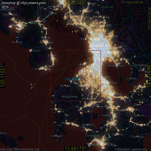
Analysis of Halayhay night lights 2016
Square area 10x10 km:
 0.22%
0.22%90-99
0.22%80-89
1.73%70-79
4.33%60-69
5.63%50-59
6.28%40-49
6.71%30-39
3.03%20-29
4.98%10-19
20.35%0-9
46.54%Square area 50x50 km:
5.4%90-99
3.81%80-89
2.63%70-79
5.89%60-69
4.76%50-59
2.2%40-49
3.2%30-39
3.03%20-29
4.1%10-19
7.19%0-9
57.79%Clear (daylight) street map image can be seen on geolist.org.
Map coordinates:
15° 3' 14.2" North, 120° 6' 36.8" East
14° 22' 26" North, 120° 48' 48" East
13° 41' 30.3" North, 121° 30' 59.3" East
Some cities around Halayhay sort by population:
• General Trias
7.5 km =4.7 mi,  78°
78°
• Kawit
12.3 km =7.6 mi,  50°
50°
• Naic
8 km =5 mi,  219°
219°
• Noveleta
9.4 km =5.8 mi, 49°
• Manggahan
13.2 km =8.2 mi,  133°
133°
• Palangue
10 km =6.2 mi,  181°
181°
• Paradahan
7.8 km =4.8 mi,  138°
138°
• Pasong Kawayan Primero
8.1 km =5 mi,  114°
114°
1711955 (p: 10,630)
Sources (retrieved 2019-11-25):
» Earth at Night: Flat Maps 2012, 2016