Balsic night lights from space
Night Light of Balsic (Central Luzon) from space (Philippines) Src. Average luminocity for 10x10km area is 19.8306% and for 50x50km: 9.035%.
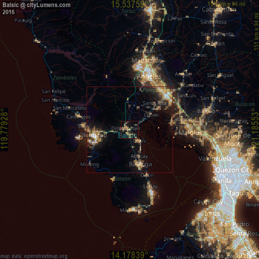
Analysis of Balsic night lights 2016
Square area 10x10 km:
 0%
0%90-99
0%80-89
0.83%70-79
4.34%60-69
5.17%50-59
3.93%40-49
5.58%30-39
6.61%20-29
2.27%10-19
11.36%0-9
59.92%Square area 50x50 km:
0.52%90-99
0.55%80-89
0.44%70-79
2.09%60-69
2.05%50-59
0.97%40-49
1.86%30-39
2.15%20-29
2.82%10-19
5.87%0-9
80.68%Clear (daylight) street map image can be seen on geolist.org.
Map coordinates:
15° 32' 15.3" North, 119° 46' 45.4" East
14° 51' 32.6" North, 120° 28' 56.6" East
14° 10' 42.2" North, 121° 11' 7.9" East
Some cities around Balsic sort by population:
• Dinalupihan
3.9 km =2.4 mi,  303°
303°
• Lubao
15.6 km =9.7 mi,  54°
54°
• Orani
8.8 km =5.5 mi,  137°
137°
• Abucay
15 km =9.3 mi,  158°
158°
• Hermosa
4.1 km =2.5 mi, 138°
• Samal
12.1 km =7.5 mi,  147°
147°
• Santa Cruz
10.8 km =6.7 mi,  56°
56°
• Santiago
5.9 km =3.7 mi,  32°
32°
1727842 (p: 5,661)
Sources (retrieved 2019-11-25):
» Earth at Night: Flat Maps 2012, 2016