Santa Cruz night lights from space
Night Light of Santa Cruz (Central Luzon) from space (Philippines) Src. Average luminocity for 10x10km area is 4.8347% and for 50x50km: 11.6662%.
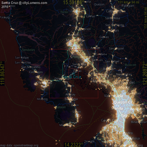
Analysis of Santa Cruz night lights 2016
Square area 10x10 km:
 0%
0%90-99
0%80-89
0%70-79
0%60-69
0.83%50-59
0%40-49
1.86%30-39
2.48%20-29
3.93%10-19
4.96%0-9
85.95%Square area 50x50 km:
0.34%90-99
0.45%80-89
0.58%70-79
2.85%60-69
2.82%50-59
1.36%40-49
2.89%30-39
2.98%20-29
4.45%10-19
8.42%0-9
72.87%Clear (daylight) street map image can be seen on geolist.org.
Map coordinates:
15° 35' 27.8" North, 119° 51' 48.5" East
14° 54' 45.7" North, 120° 33' 59.7" East
14° 13' 55.9" North, 121° 16' 11" East
Some cities around Santa Cruz sort by population:
• Lubao
4.8 km =3 mi,  50°
50°
• Hermosa
11 km =6.8 mi,  214°
214°
• Sexmoan
7 km =4.3 mi,  60°
60°
• San Roque Dau First
7.2 km =4.5 mi,  8°
8°
• Guagua
9.2 km =5.7 mi, 50°
• Pulungmasle
9.8 km =6.1 mi,  354°
354°
• Santiago
6 km =3.7 mi,  260°
260°
• Balsic
10.8 km =6.7 mi,  236°
236°
1688248 (p: 15,408)
Sources (retrieved 2019-11-25):
» Earth at Night: Flat Maps 2012, 2016