Balete night lights from space
Night Light of Balete (Calabarzon) from space (Philippines) Src. Average luminocity for 10x10km area is 7.0368% and for 50x50km: 19.416%.
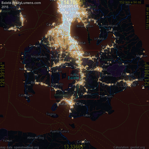
Analysis of Balete night lights 2016
Square area 10x10 km:
 0%
0%90-99
0%80-89
0%70-79
0.43%60-69
0%50-59
0%40-49
0.87%30-39
1.3%20-29
1.73%10-19
27.49%0-9
68.18%Square area 50x50 km:
0.8%90-99
1.17%80-89
1.62%70-79
5.72%60-69
3.75%50-59
2.1%40-49
3.95%30-39
3.83%20-29
5.62%10-19
16.39%0-9
55.06%Clear (daylight) street map image can be seen on geolist.org.
Map coordinates:
14° 42' 3.5" North, 120° 23' 31" East
14° 1' 11.4" North, 121° 5' 42.2" East
13° 20' 11.9" North, 121° 47' 53.5" East
Some cities around Balete sort by population:
• Tanauan
9.5 km =5.9 mi,  38°
38°
• Malvar
7.4 km =4.6 mi,  68°
68°
• Bilog-Bilog
10.5 km =6.5 mi,  356°
356°
• Ambulong
8.4 km =5.2 mi,  334°
334°
• Banaybanay
9.9 km =6.2 mi,  167°
167°
• Bulacnin
5.8 km =3.6 mi,  124°
124°
• Balele
5.1 km =3.2 mi, 358°
• Janopol
7.3 km =4.5 mi, 359°
1728240 (p: 8,662)
Sources (retrieved 2019-11-25):
» Earth at Night: Flat Maps 2012, 2016