Ambulong night lights from space
Night Light of Ambulong (Calabarzon) from space (Philippines) Src. Average luminocity for 10x10km area is 11.2749% and for 50x50km: 24.5691%.
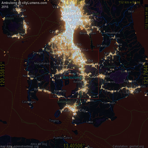
Analysis of Ambulong night lights 2016
Square area 10x10 km:
 0%
0%90-99
0%80-89
0.43%70-79
1.08%60-69
0%50-59
0.87%40-49
5.19%30-39
1.52%20-29
5.63%10-19
25.32%0-9
59.96%Square area 50x50 km:
1.49%90-99
2.19%80-89
2.3%70-79
8%60-69
5.24%50-59
2.43%40-49
4.57%30-39
3.78%20-29
6.33%10-19
15.6%0-9
48.07%Clear (daylight) street map image can be seen on geolist.org.
Map coordinates:
14° 46' 8.3" North, 120° 21' 29.3" East
14° 5' 16.9" North, 121° 3' 40.6" East
13° 24' 18.2" North, 121° 45' 51.8" East
Some cities around Ambulong sort by population:
• Tanauan
9.5 km =5.9 mi,  91°
91°
• Santo Tomas
8.9 km =5.5 mi,  75°
75°
• Talisay
4.3 km =2.7 mi,  276°
276°
• Bilog-Bilog
4.1 km =2.5 mi,  46°
46°
• Balete
8.4 km =5.2 mi,  154°
154°
• Balele
4.3 km =2.7 mi,  125°
125°
• Pantay Na Matanda
7.2 km =4.5 mi,  63°
63°
• Janopol
3.6 km =2.2 mi, 93°
1731077 (p: 9,074)
Sources (retrieved 2019-11-25):
» Earth at Night: Flat Maps 2012, 2016