Malvar night lights from space
Night Light of Malvar (Calabarzon) from space (Philippines) Src. Average luminocity for 10x10km area is 41.5195% and for 50x50km: 20.6945%.
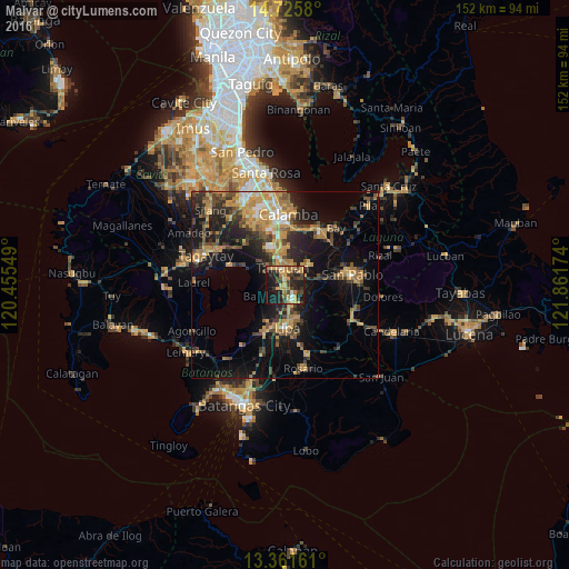

Analysis of Malvar night lights 2016
Square area 10x10 km:
 2.16%
2.16%90-99
2.16%80-89
1.95%70-79
17.97%60-69
6.49%50-59
3.03%40-49
8.66%30-39
12.55%20-29
16.02%10-19
27.27%0-9
1.73%Square area 50x50 km:
1.01%90-99
1.46%80-89
1.77%70-79
6.18%60-69
4.13%50-59
2.34%40-49
4.11%30-39
4%20-29
5.61%10-19
15.2%0-9
54.18%Clear (daylight) street map image can be seen on geolist.org.
Map coordinates:
14° 43' 32.9" North, 120° 27' 19.8" East
14° 2' 41" North, 121° 9' 31" East
13° 21' 41.8" North, 121° 51' 42.3" East
Some cities around Malvar sort by population:
• Tanauan
4.7 km =2.9 mi,  348°
348°
• Santo Tomas
7.3 km =4.5 mi, 345°
• Balete
7.4 km =4.6 mi,  248°
248°
• Bulacnin
6.4 km =4 mi,  199°
199°
• Balele
7.4 km =4.6 mi,  288°
288°
• Pantay Na Matanda
9 km =5.6 mi,  333°
333°
• San Andres
6.3 km =3.9 mi,  84°
84°
• Janopol
8.3 km =5.2 mi,  303°
303°
1702413 (p: 29,880)
Sources (retrieved 2019-11-25):
» Earth at Night: Flat Maps 2012, 2016