Junín night lights from space
Night Light of Junín (Junin) from space (Peru) Src. Average luminocity for 10x10km area is 4.4978% and for 50x50km: 0.4662%.
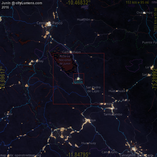
Analysis of Junín night lights 2016
Square area 10x10 km:
 0%
0%90-99
0.22%80-89
0.65%70-79
1.52%60-69
1.95%50-59
0.65%40-49
0.22%30-39
0.87%20-29
0%10-19
0%0-9
93.94%Square area 50x50 km:
0%90-99
0.01%80-89
0.07%70-79
0.19%60-69
0.11%50-59
0.14%40-49
0.04%30-39
0.08%20-29
0.03%10-19
0.03%0-9
99.3%Clear (daylight) street map image can be seen on geolist.org.
Map coordinates:
10° 28' 6" South, 76° 41' 46.2" West
11° 9' 32.2" South, 75° 59' 34.9" West
11° 50' 52.6" South, 75° 17' 23.7" West
Some cities around Junín sort by population:
• Cerro de Pasco
61.8 km =38.4 mi,  332°
332°
• Tarma
43.9 km =27.3 mi,  131°
131°
• La Oroya
41.3 km =25.7 mi,  165°
165°
• Carhuamayo
27.3 km =17 mi,  350°
350°
• Morococha
51.6 km =32.1 mi,  198°
198°
• San Pedro de Cajas
17.6 km =10.9 mi, 125°
• Huasahuasi
39.5 km =24.5 mi,  107°
107°
• Tinyahuarco
53.3 km =33.1 mi,  324°
324°
3937486 (p: 15,320)
Sources (retrieved 2019-11-25):
» Earth at Night: Flat Maps 2012, 2016