Carhuamayo night lights from space
Night Light of Carhuamayo (Junin) from space (Peru) Src. Average luminocity for 10x10km area is 2.8701% and for 50x50km: 0.6596%.
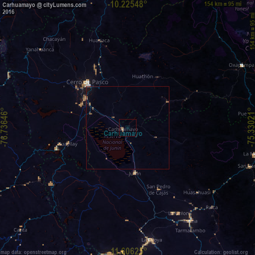
Analysis of Carhuamayo night lights 2016
Square area 10x10 km:
 0%
0%90-99
0%80-89
0.87%70-79
0%60-69
1.08%50-59
1.52%40-49
0.65%30-39
0.22%20-29
0%10-19
0%0-9
95.67%Square area 50x50 km:
0.03%90-99
0.01%80-89
0.03%70-79
0.05%60-69
0.21%50-59
0.28%40-49
0.08%30-39
0.03%20-29
0.1%10-19
0.41%0-9
98.78%Clear (daylight) street map image can be seen on geolist.org.
Map coordinates:
10° 13' 31.7" South, 76° 44' 11.3" West
10° 55' 0" South, 76° 1' 60" West
11° 36' 22.5" South, 75° 19' 48.8" West
Some cities around Carhuamayo sort by population:
• Cerro de Pasco
36.9 km =22.9 mi,  318°
318°
• Tarma
67.3 km =41.8 mi,  146°
146°
• La Oroya
68.5 km =42.6 mi,  167°
167°
• Junín
27.3 km =17 mi, 170°
• Yanahuanca
67.5 km =41.9 mi,  311°
311°
• San Pedro de Cajas
41.6 km =25.8 mi, 153°
• Huasahuasi
57.2 km =35.5 mi,  132°
132°
• Tinyahuarco
31.2 km =19.4 mi,  302°
302°
3945466 (p: 9,122)
Sources (retrieved 2019-11-25):
» Earth at Night: Flat Maps 2012, 2016