Huasahuasi night lights from space
Night Light of Huasahuasi (Junin) from space (Peru) Src. Average luminocity for 10x10km area is 1.039% and for 50x50km: 1.6843%.
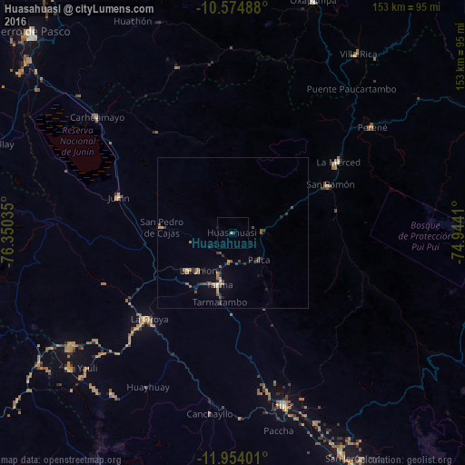
Analysis of Huasahuasi night lights 2016
Square area 10x10 km:
 0%
0%90-99
0%80-89
0%70-79
0.65%60-69
0.22%50-59
0%40-49
0%30-39
0%20-29
0.87%10-19
0.43%0-9
97.84%Square area 50x50 km:
0.05%90-99
0.05%80-89
0.06%70-79
0.37%60-69
0.34%50-59
0.35%40-49
0.48%30-39
0.27%20-29
0.54%10-19
0.38%0-9
97.1%Clear (daylight) street map image can be seen on geolist.org.
Map coordinates:
10° 34' 29.6" South, 76° 21' 1.3" West
11° 15' 55" South, 75° 38' 50" West
11° 57' 14.4" South, 74° 56' 38.8" West
Some cities around Huasahuasi sort by population:
• Tarma
17.7 km =11 mi,  195°
195°
• La Oroya
39.4 km =24.5 mi,  224°
224°
• Junín
39.5 km =24.5 mi,  287°
287°
• San Ramón
35.3 km =21.9 mi,  63°
63°
• Carhuamayo
57.2 km =35.5 mi,  312°
312°
• Perené
58.3 km =36.2 mi,  52°
52°
• Acolla
53 km =32.9 mi,  168°
168°
• San Pedro de Cajas
23.4 km =14.5 mi,  273°
273°
3939123 (p: 5,146)
Sources (retrieved 2019-11-25):
» Earth at Night: Flat Maps 2012, 2016