Ilabaya night lights from space
Night Light of Ilabaya (Tacna) from space (Peru) Src. Average luminocity for 10x10km area is 0.374% and for 50x50km: 1.7701%.
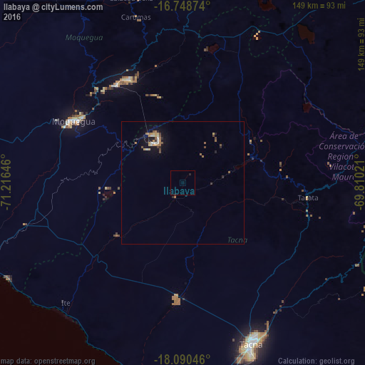
Analysis of Ilabaya night lights 2016
Square area 10x10 km:
 0%
0%90-99
0%80-89
0%70-79
0%60-69
0%50-59
0%40-49
0%30-39
0.41%20-29
0.83%10-19
0%0-9
98.76%Square area 50x50 km:
0.15%90-99
0.19%80-89
0.2%70-79
0.24%60-69
0.43%50-59
0.25%40-49
0.23%30-39
0.14%20-29
0.3%10-19
1.45%0-9
96.43%Clear (daylight) street map image can be seen on geolist.org.
Map coordinates:
16° 44' 55.5" South, 71° 12' 59.3" West
17° 25' 15" South, 70° 30' 48" West
18° 5' 25.7" South, 69° 48' 36.8" West
Some cities around Ilabaya sort by population:
• Tacna
71.5 km =44.4 mi,  157°
157°
• Arica, CL
119.4 km =74.2 mi,  168°
168°
• Moquegua
51.2 km =31.8 mi,  298°
298°
• Ilo
90.8 km =56.4 mi,  255°
255°
• Cocachacra
137.2 km =85.3 mi,  285°
285°
• Pacocha
91.6 km =56.9 mi,  254°
254°
• Torata
51.9 km =32.2 mi,  317°
317°
• Punta de Bombón
138.6 km =86.1 mi,  281°
281°
3938455 (p: 9,492)
Sources (retrieved 2019-11-25):
» Earth at Night: Flat Maps 2012, 2016