Acolla night lights from space
Night Light of Acolla (Junin) from space (Peru) Src. Average luminocity for 10x10km area is 11.0537% and for 50x50km: 2.5623%.
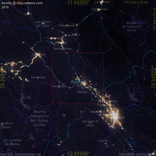
Analysis of Acolla night lights 2016
Square area 10x10 km:
 0%
0%90-99
0.21%80-89
0%70-79
1.24%60-69
3.93%50-59
4.55%40-49
3.31%30-39
1.03%20-29
0.83%10-19
2.69%0-9
82.23%Square area 50x50 km:
0.02%90-99
0.1%80-89
0%70-79
0.46%60-69
0.83%50-59
0.61%40-49
0.59%30-39
0.41%20-29
0.49%10-19
1%0-9
95.49%Clear (daylight) street map image can be seen on geolist.org.
Map coordinates:
11° 2' 33.5" South, 76° 14' 58.1" West
11° 43' 54.9" South, 75° 32' 46.8" West
12° 25' 10.2" South, 74° 50' 35.6" West
Some cities around Acolla sort by population:
• Tarma
38.1 km =23.7 mi,  335°
335°
• La Oroya
45.2 km =28.1 mi,  301°
301°
• Jauja
7.3 km =4.5 mi,  132°
132°
• Concepción
32.6 km =20.3 mi, 129°
• Chupaca
46.9 km =29.1 mi,  142°
142°
• San Jerónimo
37.9 km =23.5 mi, 131°
• Sicaya
44.1 km =27.4 mi, 139°
• San Agustin
41.4 km =25.7 mi, 130°
3948448 (p: 6,805)
Sources (retrieved 2019-11-25):
» Earth at Night: Flat Maps 2012, 2016