Taradale night lights from space
Night Light of Taradale (Hawke's Bay) from space (New Zealand) Src. Average luminocity for 10x10km area is 29.1364% and for 50x50km: 4.4196%.
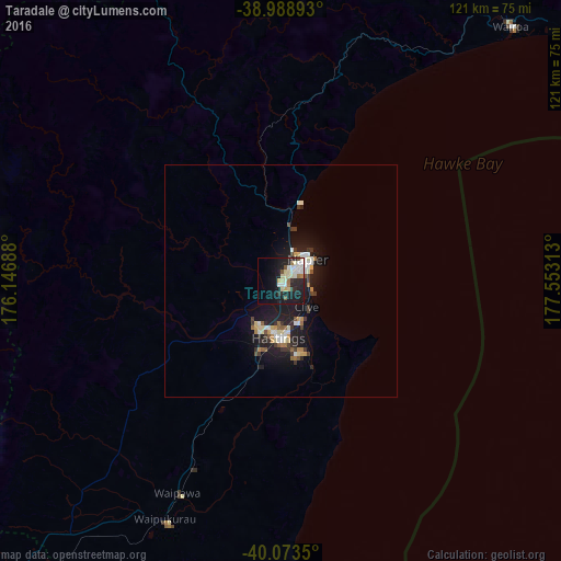
Analysis of Taradale night lights 2016
Square area 10x10 km:
 1.62%
1.62%90-99
10.55%80-89
5.36%70-79
1.3%60-69
2.92%50-59
1.62%40-49
1.3%30-39
1.79%20-29
9.74%10-19
31.01%0-9
32.79%Square area 50x50 km:
0.37%90-99
1.01%80-89
0.6%70-79
0.31%60-69
0.42%50-59
0.44%40-49
0.28%30-39
0.82%20-29
0.99%10-19
5.44%0-9
89.31%Clear (daylight) street map image can be seen on geolist.org.
Map coordinates:
38° 59' 20.1" South, 176° 8' 48.8" East
39° 31' 60" South, 176° 51' 0" East
40° 4' 24.6" South, 177° 33' 11.3" East
Some cities around Taradale sort by population:
• Palmerston North
139.7 km =86.8 mi,  229°
229°
• Hastings
11.6 km =7.2 mi,  180°
180°
• Napier
7 km =4.3 mi,  49°
49°
• Wanganui
160.2 km =99.5 mi,  253°
253°
• Gisborne
139.6 km =86.7 mi, 45°
• Taupo
115.4 km =71.7 mi,  325°
325°
• Kawerau
159.9 km =99.4 mi,  355°
355°
• Linton Military Camp
144.9 km =90 mi, 228°
6246634 (p: 16,599)
Sources (retrieved 2019-11-25):
» Earth at Night: Flat Maps 2012, 2016