Volda night lights from space
Night Light of Volda (Møre og Romsdal) from space (Norway) Src. Average luminocity for 10x10km area is 9.3389% and for 50x50km: 1.7516%.
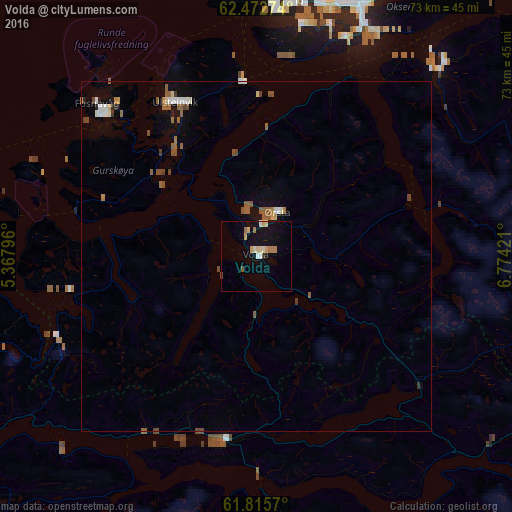
Analysis of Volda night lights 2016
Square area 10x10 km:
 0.69%
0.69%90-99
1.48%80-89
1.58%70-79
1.38%60-69
1.58%50-59
0.79%40-49
0.2%30-39
0.4%20-29
0%10-19
9.09%0-9
82.81%Square area 50x50 km:
0.14%90-99
0.3%80-89
0.14%70-79
0.1%60-69
0.26%50-59
0.51%40-49
0.35%30-39
0.1%20-29
0.07%10-19
0.73%0-9
97.29%Clear (daylight) street map image can be seen on geolist.org.
Map coordinates:
62° 28' 21.9" North, 5° 22' 4.7" East
62° 8' 45.6" North, 6° 4' 15.9" East
61° 48' 56.5" North, 6° 46' 27.2" East
Some cities around Volda sort by population:
• Ålesund
36.5 km =22.7 mi,  6°
6°
• Molde
86.4 km =53.7 mi,  40°
40°
• Førde
78 km =48.5 mi,  188°
188°
• Florø
81.6 km =50.7 mi,  221°
221°
• Sogndal
115.4 km =71.7 mi,  152°
152°
• Ørsta
6.7 km =4.2 mi,  26°
26°
• Ulsteinvik
24.8 km =15.4 mi,  332°
332°
• Hermansverk
114.5 km =71.1 mi,  158°
158°
3131449 (p: 5,376)
Sources (retrieved 2019-11-25):
» Earth at Night: Flat Maps 2012, 2016