Stein night lights from space
Night Light of Stein (Limburg) from space (Netherlands) Src. Average luminocity for 10x10km area is 61.619% and for 50x50km: 28.8695%.
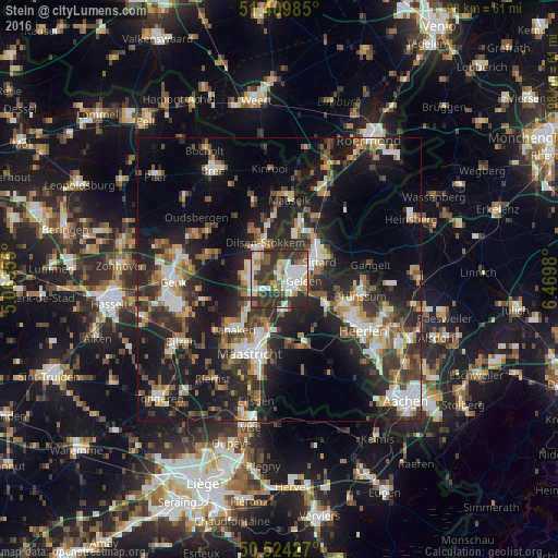
Analysis of Stein night lights 2016
Square area 10x10 km:
100  15.97%
90-99 15.27%
80-89 4.76%
70-79 4.9%
60-69 8.54%
50-59 4.62%
40-49 8.54%
30-39 23.39%
20-29 14.01%
10-19 0%
0-9 0%
15.97%90-99
15.27%80-89
4.76%70-79
4.9%60-69
8.54%50-59
4.62%40-49
8.54%30-39
23.39%20-29
14.01%10-19
0%0-9
0%Square area 50x50 km:
100 3.83%
90-99 5.26%
80-89 2.37%
70-79 3.02%
60-69 3.9%
50-59 4.23%
40-49 4.46%
30-39 5.78%
20-29 11.09%
10-19 21.82%
0-9 34.23%
3.83%90-99
5.26%80-89
2.37%70-79
3.02%60-69
3.9%50-59
4.23%40-49
4.46%30-39
5.78%20-29
11.09%10-19
21.82%0-9
34.23%Clear (daylight) street map image can be seen on geolist.org.
Map coordinates:
51° 24' 35.5" North, 5° 3' 48.8" East
50° 58' 9" North, 5° 46' 0" East
50° 31' 27.4" North, 6° 28' 11.3" East
Some cities around Stein sort by population:
• Sittard
7.9 km =4.9 mi,  65°
65°
• Maasmechelen, BE
5.1 km =3.2 mi,  265°
265°
• Geleen
4.4 km =2.7 mi,  82°
82°
• Beek
3.8 km =2.4 mi,  145°
145°
• Lindenheuvel
3.9 km =2.4 mi,  63°
63°
• Elsloo
2.2 km =1.4 mi,  172°
172°
• Meerssen
9.2 km =5.7 mi,  187°
187°
• Bunde
8.4 km =5.2 mi,  196°
196°
2746748 (p: 11,290)
Sources (retrieved 2019-11-25):
» Earth at Night: Flat Maps 2012, 2016