Bunde night lights from space
Night Light of Bunde (Limburg) from space (Netherlands) Src. Average luminocity for 10x10km area is 50.2885% and for 50x50km: 30.0901%.
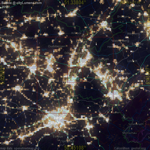
Analysis of Bunde night lights 2016
Square area 10x10 km:
100  9.66%
9.66%
90-99 10.78%
80-89 4.2%
70-79 3.92%
60-69 5.18%
50-59 4.76%
40-49 9.38%
30-39 17.23%
20-29 24.79%
10-19 9.94%
0-9 0.14%
9.66%90-99
10.78%80-89
4.2%70-79
3.92%60-69
5.18%50-59
4.76%40-49
9.38%30-39
17.23%20-29
24.79%10-19
9.94%0-9
0.14%Square area 50x50 km:
100 3.97%
90-99 5.41%
80-89 2.35%
70-79 2.99%
60-69 4.3%
50-59 4.34%
40-49 4.65%
30-39 6.49%
20-29 12.62%
10-19 22.23%
0-9 30.67%
3.97%90-99
5.41%80-89
2.35%70-79
2.99%60-69
4.3%50-59
4.34%40-49
4.65%30-39
6.49%20-29
12.62%10-19
22.23%0-9
30.67%Clear (daylight) street map image can be seen on geolist.org.
Map coordinates:
51° 20' 16.9" North, 5° 1' 43.8" East
50° 53' 48" North, 5° 43' 55" East
50° 27' 3.9" North, 6° 26' 6.3" East
Some cities around Bunde sort by population:
• Maastricht
6.2 km =3.9 mi,  209°
209°
• Lanaken, BE
6 km =3.7 mi,  266°
266°
• Beek
6.7 km =4.2 mi,  42°
42°
• Heer
6.5 km =4 mi,  181°
181°
• Elsloo
6.4 km =4 mi,  25°
25°
• Scharn
5.2 km =3.2 mi, 178°
• Amby
3.8 km =2.4 mi, 179°
• Meerssen
1.6 km =1 mi,  128°
128°
2758111 (p: 5,500)
Sources (retrieved 2019-11-25):
» Earth at Night: Flat Maps 2012, 2016