Elsloo night lights from space
Night Light of Elsloo (Limburg) from space (Netherlands) Src. Average luminocity for 10x10km area is 57.4076% and for 50x50km: 28.9502%.
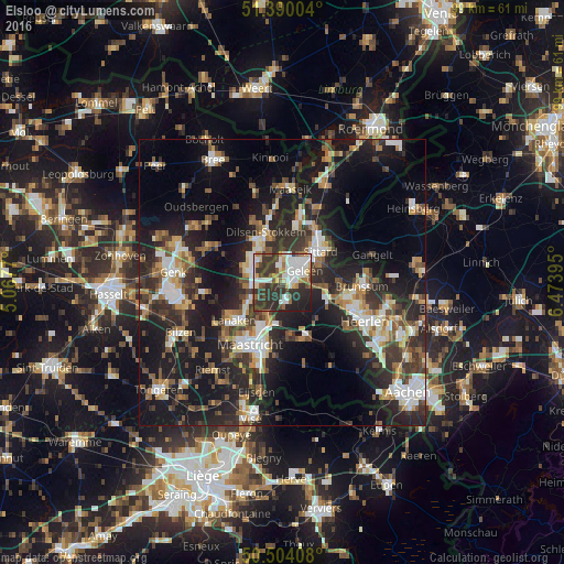
Analysis of Elsloo night lights 2016
Square area 10x10 km:
100  14.99%
90-99 13.73%
80-89 4.34%
70-79 4.48%
60-69 6.58%
50-59 3.22%
40-49 8.12%
30-39 19.75%
20-29 21.01%
10-19 3.78%
0-9 0%
14.99%90-99
13.73%80-89
4.34%70-79
4.48%60-69
6.58%50-59
3.22%40-49
8.12%30-39
19.75%20-29
21.01%10-19
3.78%0-9
0%Square area 50x50 km:
100 3.86%
90-99 5.25%
80-89 2.27%
70-79 3.04%
60-69 3.86%
50-59 4.2%
40-49 4.46%
30-39 5.86%
20-29 11.64%
10-19 22.3%
0-9 33.26%
3.86%90-99
5.25%80-89
2.27%70-79
3.04%60-69
3.86%50-59
4.2%40-49
4.46%30-39
5.86%20-29
11.64%10-19
22.3%0-9
33.26%Clear (daylight) street map image can be seen on geolist.org.
Map coordinates:
51° 23' 24.1" North, 5° 4' 3.7" East
50° 56' 57" North, 5° 46' 15" East
50° 30' 14.7" North, 6° 28' 26.2" East
Some cities around Elsloo sort by population:
• Sittard
8.8 km =5.5 mi,  51°
51°
• Maasmechelen, BE
5.6 km =3.5 mi,  288°
288°
• Geleen
4.9 km =3 mi,  55°
55°
• Stein
2.2 km =1.4 mi,  352°
352°
• Beek
2.1 km =1.3 mi,  116°
116°
• Lindenheuvel
5.1 km =3.2 mi,  38°
38°
• Meerssen
7 km =4.3 mi,  192°
192°
• Bunde
6.4 km =4 mi,  205°
205°
2756169 (p: 7,220)
Sources (retrieved 2019-11-25):
» Earth at Night: Flat Maps 2012, 2016