Schoonhoven night lights from space
Night Light of Schoonhoven (South Holland) from space (Netherlands) Src. Average luminocity for 10x10km area is 8.7361% and for 50x50km: 36.3409%.
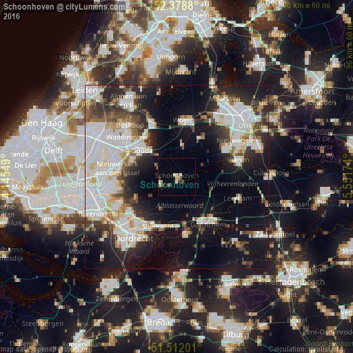
Analysis of Schoonhoven night lights 2016
Square area 10x10 km:
 0.25%
0.25%90-99
1.52%80-89
0.88%70-79
1.39%60-69
0.51%50-59
2.27%40-49
1.64%30-39
1.64%20-29
0.13%10-19
0.38%0-9
89.39%Square area 50x50 km:
11.15%90-99
8.74%80-89
2.83%70-79
2.59%60-69
2.71%50-59
3%40-49
3.88%30-39
4.52%20-29
7.6%10-19
17.75%0-9
35.23%Clear (daylight) street map image can be seen on geolist.org.
Map coordinates:
52° 22' 43.7" North, 4° 8' 43.8" East
51° 56' 51" North, 4° 50' 55" East
51° 30' 43.2" North, 5° 33' 6.3" East
Some cities around Schoonhoven sort by population:
• Gouda
12.3 km =7.6 mi,  308°
308°
• Lopik
7.4 km =4.6 mi,  67°
67°
• Oudewater
8.7 km =5.4 mi,  8°
8°
• Liesveld
2 km =1.2 mi,  214°
214°
• Nieuw-Lekkerland
12.9 km =8 mi,  239°
239°
• Montfoort
13.1 km =8.1 mi,  33°
33°
• Neder-Hardinxveld
13.2 km =8.2 mi,  178°
178°
• Giessendam
12.8 km =8 mi, 183°
2747506 (p: 12,352)
Sources (retrieved 2019-11-25):
» Earth at Night: Flat Maps 2012, 2016