Nieuw-Lekkerland night lights from space
Night Light of Nieuw-Lekkerland (South Holland) from space (Netherlands) Src. Average luminocity for 10x10km area is 36.4697% and for 50x50km: 41.3267%.
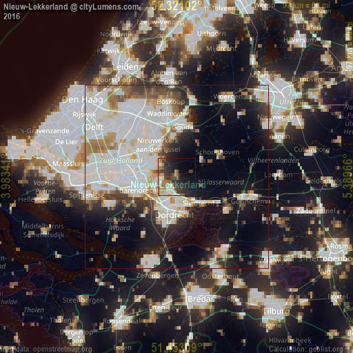
Analysis of Nieuw-Lekkerland night lights 2016
Square area 10x10 km:
 6.82%
6.82%90-99
4.29%80-89
3.28%70-79
5.68%60-69
5.56%50-59
3.28%40-49
4.29%30-39
12.37%20-29
14.27%10-19
17.17%0-9
22.98%Square area 50x50 km:
14.81%90-99
10.57%80-89
3.11%70-79
3.05%60-69
3.95%50-59
2.94%40-49
3.06%30-39
3.83%20-29
5.37%10-19
13.76%0-9
35.55%Clear (daylight) street map image can be seen on geolist.org.
Map coordinates:
52° 19' 15.7" North, 3° 59' 0.3" East
51° 53' 20.9" North, 4° 41' 11.5" East
51° 27' 11.1" North, 5° 23' 22.8" East
Some cities around Nieuw-Lekkerland sort by population:
• Capelle aan den IJssel
8.7 km =5.4 mi,  300°
300°
• Ridderkerk
6 km =3.7 mi,  252°
252°
• Papendrecht
6.4 km =4 mi,  179°
179°
• Krimpen aan den IJssel
6.5 km =4 mi, 298°
• Hendrik-Ido-Ambacht
6 km =3.7 mi,  213°
213°
• Alblasserdam
3.1 km =1.9 mi, 213°
• Slikkerveer
5.6 km =3.5 mi,  265°
265°
• Bolnes
7.4 km =4.6 mi,  275°
275°
2750163 (p: 9,535)
Sources (retrieved 2019-11-25):
» Earth at Night: Flat Maps 2012, 2016