Montfoort night lights from space
Night Light of Montfoort (Utrecht) from space (Netherlands) Src. Average luminocity for 10x10km area is 21.1604% and for 50x50km: 32.9807%.
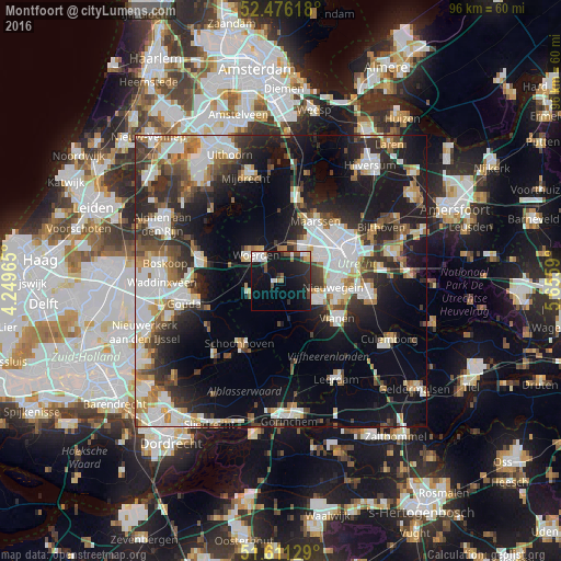
Analysis of Montfoort night lights 2016
Square area 10x10 km:
 3.28%
3.28%90-99
3.79%80-89
1.01%70-79
0.51%60-69
1.52%50-59
2.9%40-49
3.16%30-39
2.4%20-29
8.08%10-19
34.34%0-9
39.02%Square area 50x50 km:
7.24%90-99
7.17%80-89
2.78%70-79
3.14%60-69
3.61%50-59
3.26%40-49
4.45%30-39
4.81%20-29
9.26%10-19
18.62%0-9
35.66%Clear (daylight) street map image can be seen on geolist.org.
Map coordinates:
52° 28' 34.2" North, 4° 14' 58.7" East
52° 2' 45" North, 4° 57' 10" East
51° 36' 40.6" North, 5° 39' 21.2" East
Some cities around Montfoort sort by population:
• Nieuwegein
8.9 km =5.5 mi,  101°
101°
• Woerden
6.4 km =4 mi,  312°
312°
• IJsselstein
6.8 km =4.2 mi,  114°
114°
• Vianen
11.2 km =7 mi,  121°
121°
• Lopik
8.2 km =5.1 mi,  182°
182°
• Oudewater
6.2 km =3.9 mi,  248°
248°
• Veldhuizen
5.2 km =3.2 mi,  51°
51°
• Vleuten
7.9 km =4.9 mi,  32°
32°
2750626 (p: 5,500)
Sources (retrieved 2019-11-25):
» Earth at Night: Flat Maps 2012, 2016