Lopik night lights from space
Night Light of Lopik (Utrecht) from space (Netherlands) Src. Average luminocity for 10x10km area is 2.4886% and for 50x50km: 30.9508%.
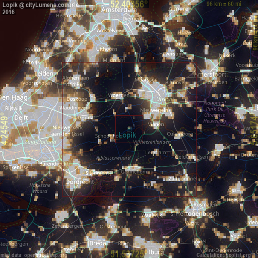
Analysis of Lopik night lights 2016
Square area 10x10 km:
 0%
0%90-99
0%80-89
0%70-79
0%60-69
0%50-59
0.13%40-49
0.88%30-39
0%20-29
1.14%10-19
2.9%0-9
94.95%Square area 50x50 km:
6.87%90-99
6.48%80-89
2.85%70-79
2.66%60-69
2.97%50-59
2.94%40-49
4.05%30-39
4.25%20-29
9.13%10-19
20.07%0-9
37.74%Clear (daylight) street map image can be seen on geolist.org.
Map coordinates:
52° 24' 12.8" North, 4° 14' 43.8" East
51° 58' 21" North, 4° 56' 55" East
51° 32' 14.1" North, 5° 39' 6.3" East
Some cities around Lopik sort by population:
• Nieuwegein
11 km =6.8 mi,  55°
55°
• IJsselstein
8.3 km =5.2 mi,  50°
50°
• Vianen
10 km =6.2 mi,  77°
77°
• Schoonhoven
7.4 km =4.6 mi,  247°
247°
• Oudewater
8 km =5 mi,  316°
316°
• Liesveld
9.1 km =5.7 mi,  240°
240°
• Veldhuizen
12.2 km =7.6 mi,  20°
20°
• Montfoort
8.2 km =5.1 mi,  2°
2°
2751436 (p: 14,013)
Sources (retrieved 2019-11-25):
» Earth at Night: Flat Maps 2012, 2016