Coevering night lights from space
Night Light of Coevering (North Brabant) from space (Netherlands) Src. Average luminocity for 10x10km area is 37.5348% and for 50x50km: 19.9014%.
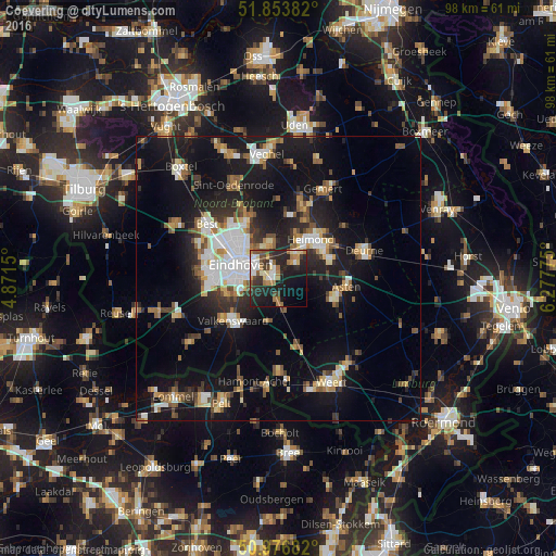
Analysis of Coevering night lights 2016
Square area 10x10 km:
 4.68%
4.68%90-99
6.02%80-89
4.95%70-79
2.94%60-69
8.29%50-59
3.48%40-49
5.35%30-39
6.28%20-29
19.65%10-19
23.8%0-9
14.57%Square area 50x50 km:
2.84%90-99
3.38%80-89
1.98%70-79
2.13%60-69
2.2%50-59
2.97%40-49
2.31%30-39
2.62%20-29
5.04%10-19
18.76%0-9
55.76%Clear (daylight) street map image can be seen on geolist.org.
Map coordinates:
51° 51' 13.8" North, 4° 52' 17.4" East
51° 25' 2.7" North, 5° 34' 28.7" East
50° 58' 36.6" North, 6° 16' 39.9" East
Some cities around Coevering sort by population:
• Eindhoven
7.2 km =4.5 mi,  291°
291°
• Geldrop
1.1 km =0.7 mi, 294°
• Nuenen
6 km =3.7 mi,  345°
345°
• Tongelre
5.2 km =3.2 mi,  312°
312°
• Mierlo
4 km =2.5 mi,  51°
51°
• Heeze
3.9 km =2.4 mi,  183°
183°
• De Doornakkers
5.1 km =3.2 mi,  297°
297°
• Vaartbroek
8.7 km =5.4 mi,  322°
322°
2757938 (p: 5,290)
Sources (retrieved 2019-11-25):
» Earth at Night: Flat Maps 2012, 2016