Vaartbroek night lights from space
Night Light of Vaartbroek (North Brabant) from space (Netherlands) Src. Average luminocity for 10x10km area is 66.7246% and for 50x50km: 21.9069%.
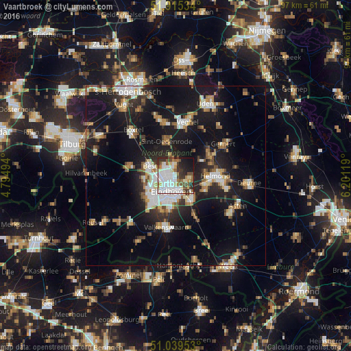
Analysis of Vaartbroek night lights 2016
Square area 10x10 km:
 21.93%
90-99
20.32%80-89
5.48%70-79
4.55%60-69
4.41%50-59
8.02%40-49
6.42%30-39
10.03%20-29
7.75%10-19
10.16%0-9
0.94%Square area 50x50 km:
3.3%90-99
4.03%80-89
1.98%70-79
2.33%60-69
2.63%50-59
2.85%40-49
2.29%30-39
2.83%20-29
6.03%10-19
20.91%0-9
50.82%Clear (daylight) street map image can be seen on geolist.org.
Map coordinates:
51° 54' 55.2" North, 4° 47' 41.8" East
51° 28' 46.3" North, 5° 29' 53" East
51° 2' 22.3" North, 6° 12' 4.3" East
Some cities around Vaartbroek sort by population:
• Eindhoven
4.5 km =2.8 mi,  198°
198°
• Geldrop
7.7 km =4.8 mi,  146°
146°
• Nuenen
3.9 km =2.4 mi,  105°
105°
• Tongelre
3.7 km =2.3 mi,  156°
156°
• Meerhoven
7.3 km =4.5 mi,  235°
235°
• De Doornakkers
4.6 km =2.9 mi,  170°
170°
• Grasrijk
7.3 km =4.5 mi,  231°
231°
• Woenselse Heide
2.2 km =1.4 mi,  280°
280°
2745896 (p: 5,200)
Sources (retrieved 2019-11-25):
» Earth at Night: Flat Maps 2012, 2016