Budel night lights from space
Night Light of Budel (North Brabant) from space (Netherlands) Src. Average luminocity for 10x10km area is 14.8613% and for 50x50km: 19.419%.
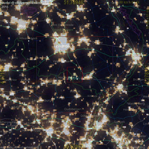
Analysis of Budel night lights 2016
Square area 10x10 km:
 0.28%
0.28%90-99
0.84%80-89
1.82%70-79
2.66%60-69
1.4%50-59
4.34%40-49
3.78%30-39
1.12%20-29
1.12%10-19
3.08%0-9
79.55%Square area 50x50 km:
2.72%90-99
3.14%80-89
1.98%70-79
2.07%60-69
1.94%50-59
2.71%40-49
2.95%30-39
2.64%20-29
4.51%10-19
16.75%0-9
58.6%Clear (daylight) street map image can be seen on geolist.org.
Map coordinates:
51° 42' 34.1" North, 4° 52' 18.7" East
51° 16' 18" North, 5° 34' 30" East
50° 49' 46.8" North, 6° 16' 41.2" East
Some cities around Budel sort by population:
• Weert
9.4 km =5.8 mi,  103°
103°
• Valkenswaard
11.9 km =7.4 mi,  317°
317°
• Cranendonck
3.7 km =2.3 mi,  14°
14°
• Neerpelt, BE
10.4 km =6.5 mi,  242°
242°
• Overpelt, BE
13 km =8.1 mi, 238°
• Bocholt, BE
10.9 km =6.8 mi,  178°
178°
• Heeze
12.4 km =7.7 mi,  358°
358°
• Nederweert
12.2 km =7.6 mi,  82°
82°
2758166 (p: 7,895)
Sources (retrieved 2019-11-25):
» Earth at Night: Flat Maps 2012, 2016