Nederweert night lights from space
Night Light of Nederweert (Limburg) from space (Netherlands) Src. Average luminocity for 10x10km area is 20.0364% and for 50x50km: 19.6695%.
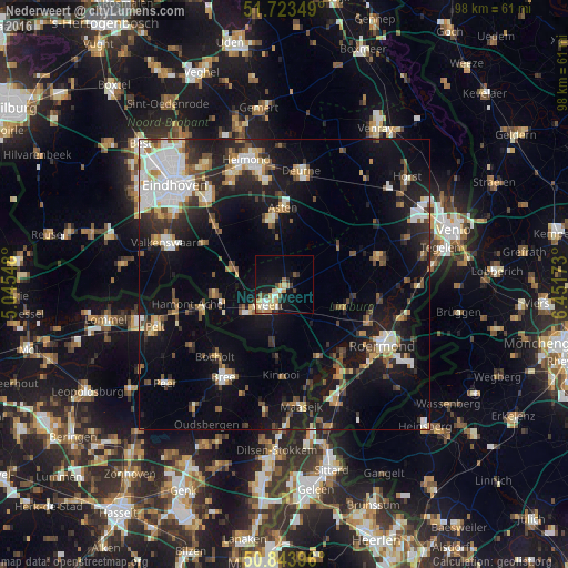
Analysis of Nederweert night lights 2016
Square area 10x10 km:
 1.54%
1.54%90-99
3.08%80-89
5.88%70-79
2.94%60-69
1.68%50-59
1.96%40-49
1.82%30-39
2.66%20-29
1.12%10-19
16.67%0-9
60.64%Square area 50x50 km:
3.02%90-99
3.47%80-89
2.03%70-79
1.87%60-69
1.91%50-59
2.48%40-49
2.75%30-39
2.62%20-29
4.93%10-19
16%0-9
58.92%Clear (daylight) street map image can be seen on geolist.org.
Map coordinates:
51° 43' 24.6" North, 5° 2' 43.7" East
51° 17' 9" North, 5° 44' 55" East
50° 50' 38.3" North, 6° 27' 6.2" East
Some cities around Nederweert sort by population:
• Weert
4.8 km =3 mi,  217°
217°
• Cranendonck
11.3 km =7 mi,  280°
280°
• Someren
11.3 km =7 mi,  346°
346°
• Haelen
15.5 km =9.6 mi,  110°
110°
• Asten
13.2 km =8.2 mi,  0°
0°
• Budel
12.2 km =7.6 mi,  262°
262°
• Heythuysen
11.2 km =7 mi, 110°
• Meijel
11.5 km =7.1 mi,  55°
55°
2750467 (p: 7,205)
Sources (retrieved 2019-11-25):
» Earth at Night: Flat Maps 2012, 2016