Neerpelt night lights from space
Night Light of Neerpelt (Flanders) from space (Belgium) Src. Average luminocity for 10x10km area is 24.9986% and for 50x50km: 20.7661%.
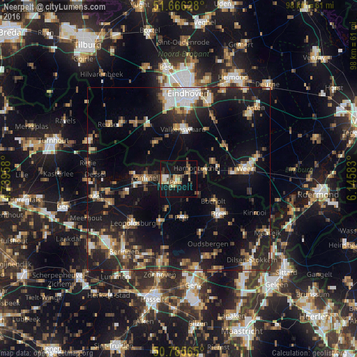
Analysis of Neerpelt night lights 2016
Square area 10x10 km:
 1.96%
1.96%90-99
1.54%80-89
4.9%70-79
5.04%60-69
1.68%50-59
3.08%40-49
5.6%30-39
3.64%20-29
2.24%10-19
34.03%0-9
36.27%Square area 50x50 km:
2.24%90-99
2.75%80-89
2.14%70-79
2.64%60-69
2.16%50-59
3.11%40-49
3.36%30-39
3.15%20-29
6.91%10-19
18.91%0-9
52.62%Clear (daylight) street map image can be seen on geolist.org.
Map coordinates:
51° 39' 58.6" North, 4° 44' 22.5" East
51° 13' 41.1" North, 5° 26' 33.7" East
50° 47' 8.3" North, 6° 8' 45" East
Some cities around Neerpelt sort by population:
• Lommel
9 km =5.6 mi,  271°
271°
• Valkenswaard, NL
13.7 km =8.5 mi,  4°
4°
• Cranendonck, NL
13.2 km =8.2 mi,  50°
50°
• Bergeijk, NL
11.7 km =7.3 mi,  329°
329°
• Peer
10.9 km =6.8 mi,  173°
173°
• Overpelt
2.7 km =1.7 mi,  223°
223°
• Bocholt
11.3 km =7 mi,  122°
122°
• Budel, NL
10.4 km =6.5 mi,  62°
62°
2790357 (p: 16,122)
Sources (retrieved 2019-11-25):
» Earth at Night: Flat Maps 2012, 2016