Bemmel night lights from space
Night Light of Bemmel (Gelderland) from space (Netherlands) Src. Average luminocity for 10x10km area is 41.0783% and for 50x50km: 20.1871%.
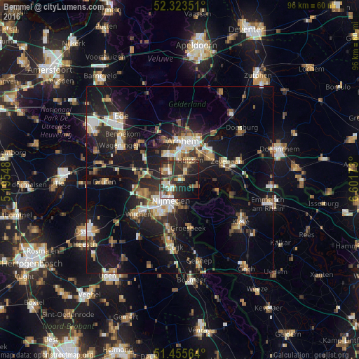
Analysis of Bemmel night lights 2016
Square area 10x10 km:
100  6.06%
6.06%
90-99 5.56%
80-89 4.8%
70-79 4.42%
60-69 6.31%
50-59 3.66%
40-49 6.06%
30-39 15.53%
20-29 21.97%
10-19 17.17%
0-9 8.46%
6.06%90-99
5.56%80-89
4.8%70-79
4.42%60-69
6.31%50-59
3.66%40-49
6.06%30-39
15.53%20-29
21.97%10-19
17.17%0-9
8.46%Square area 50x50 km:
100 2.49%
90-99 3.17%
80-89 2.12%
70-79 1.99%
60-69 2.79%
50-59 2.71%
40-49 2.58%
30-39 2.96%
20-29 6.88%
10-19 19.17%
0-9 53.14%
2.49%90-99
3.17%80-89
2.12%70-79
1.99%60-69
2.79%50-59
2.71%40-49
2.58%30-39
2.96%20-29
6.88%10-19
19.17%0-9
53.14%Clear (daylight) street map image can be seen on geolist.org.
Map coordinates:
52° 19' 24.6" North, 5° 11' 43.7" East
51° 53' 30" North, 5° 53' 55" East
51° 27' 20.3" North, 6° 36' 6.2" East
Some cities around Bemmel sort by population:
• Nijmegen
6.3 km =3.9 mi,  209°
209°
• Beuningen
9.7 km =6 mi,  249°
249°
• Elst
5 km =3.1 mi,  308°
308°
• Lindenholt
9.8 km =6.1 mi,  227°
227°
• Lent
4 km =2.5 mi, 213°
• Hengstdal
6.6 km =4.1 mi,  189°
189°
• Westervoort
8.7 km =5.4 mi,  35°
35°
• Gendt
5.2 km =3.2 mi,  107°
107°
2759231 (p: 12,020)
Sources (retrieved 2019-11-25):
» Earth at Night: Flat Maps 2012, 2016