Hengstdal night lights from space
Night Light of Hengstdal (Gelderland) from space (Netherlands) Src. Average luminocity for 10x10km area is 45.5686% and for 50x50km: 21.374%.
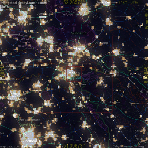
Analysis of Hengstdal night lights 2016
Square area 10x10 km:
 11.62%
90-99
13.59%80-89
3.08%70-79
2.24%60-69
2.8%50-59
4.62%40-49
4.06%30-39
10.5%20-29
14.85%10-19
16.39%0-9
16.25%Square area 50x50 km:
2.72%90-99
3.51%80-89
2.36%70-79
2.21%60-69
2.86%50-59
2.83%40-49
2.65%30-39
3.1%20-29
6.68%10-19
19.41%0-9
51.69%Clear (daylight) street map image can be seen on geolist.org.
Map coordinates:
52° 15' 56.6" North, 5° 10' 48.8" East
51° 49' 60" North, 5° 52' 60" East
51° 23' 48.2" North, 6° 35' 11.3" East
Some cities around Hengstdal sort by population:
• Nijmegen
2.3 km =1.4 mi,  295°
295°
• Beuningen
8.6 km =5.3 mi,  290°
290°
• Groesbeek
7.3 km =4.5 mi,  150°
150°
• Lindenholt
6.2 km =3.9 mi,  269°
269°
• Bemmel
6.6 km =4.1 mi,  9°
9°
• Hatert
4.7 km =2.9 mi,  230°
230°
• Lent
3.4 km =2.1 mi,  340°
340°
• Gendt
7.8 km =4.8 mi,  50°
50°
2754386 (p: 7,010)
Sources (retrieved 2019-11-25):
» Earth at Night: Flat Maps 2012, 2016