Gendt night lights from space
Night Light of Gendt (Gelderland) from space (Netherlands) Src. Average luminocity for 10x10km area is 15.0985% and for 50x50km: 19.1378%.
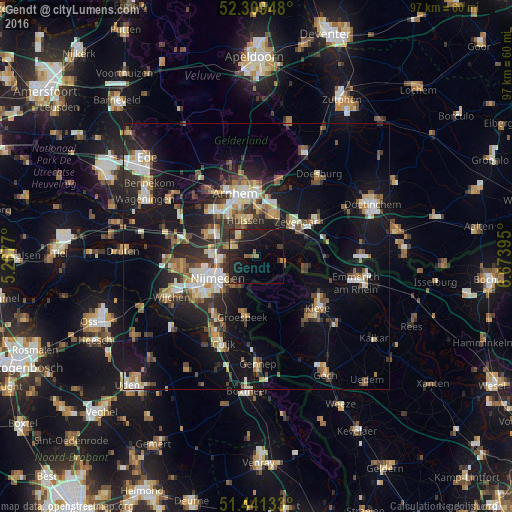
Analysis of Gendt night lights 2016
Square area 10x10 km:
100  0.38%
0.38%
90-99 0.63%
80-89 1.77%
70-79 0.76%
60-69 2.9%
50-59 1.77%
40-49 0.51%
30-39 3.16%
20-29 10.35%
10-19 27.53%
0-9 50.25%
0.38%90-99
0.63%80-89
1.77%70-79
0.76%60-69
2.9%50-59
1.77%40-49
0.51%30-39
3.16%20-29
10.35%10-19
27.53%0-9
50.25%Square area 50x50 km:
100 2.38%
90-99 3.08%
80-89 2.06%
70-79 1.79%
60-69 2.6%
50-59 2.62%
40-49 2.56%
30-39 2.86%
20-29 6.1%
10-19 17.14%
0-9 56.8%
2.38%90-99
3.08%80-89
2.06%70-79
1.79%60-69
2.6%50-59
2.62%40-49
2.56%30-39
2.86%20-29
6.1%10-19
17.14%0-9
56.8%Clear (daylight) street map image can be seen on geolist.org.
Map coordinates:
52° 18' 34.1" North, 5° 16' 3.7" East
51° 52' 39" North, 5° 58' 15" East
51° 26' 28.8" North, 6° 40' 26.2" East
Some cities around Gendt sort by population:
• Nijmegen
9 km =5.6 mi,  244°
244°
• Zevenaar
9 km =5.6 mi,  49°
49°
• Duiven
8.2 km =5.1 mi,  21°
21°
• Elst
10 km =6.2 mi,  297°
297°
• Bemmel
5.2 km =3.2 mi,  287°
287°
• Lent
7.4 km =4.6 mi,  256°
256°
• Hengstdal
7.8 km =4.8 mi,  230°
230°
• Westervoort
8.7 km =5.4 mi,  0°
0°
2755597 (p: 5,590)
Sources (retrieved 2019-11-25):
» Earth at Night: Flat Maps 2012, 2016