Somotillo night lights from space
Night Light of Somotillo (Chinandega) from space (Nicaragua) Src. Average luminocity for 10x10km area is 2.9069% and for 50x50km: 0.348%.
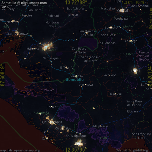
Analysis of Somotillo night lights 2016
Square area 10x10 km:
 0%
0%90-99
0%80-89
0.65%70-79
1.08%60-69
0%50-59
1.73%40-49
0%30-39
0%20-29
0.87%10-19
0%0-9
95.67%Square area 50x50 km:
0%90-99
0%80-89
0.04%70-79
0.09%60-69
0.03%50-59
0.11%40-49
0.06%30-39
0.1%20-29
0.15%10-19
0.08%0-9
99.32%Clear (daylight) street map image can be seen on geolist.org.
Map coordinates:
13° 43' 40.4" North, 87° 36' 29.5" West
13° 2' 37.9" North, 86° 54' 18.2" West
12° 21' 28.6" North, 86° 12' 7" West
Some cities around Somotillo sort by population:
• Chinandega
52.2 km =32.4 mi,  207°
207°
• Ciudad Choluteca, HN
42.1 km =26.2 mi,  312°
312°
• El Viejo
50.9 km =31.6 mi, 213°
• Chichigalpa
53.5 km =33.2 mi,  194°
194°
• El Sauce
43.3 km =26.9 mi,  113°
113°
• San Marcos de Colón, HN
44.8 km =27.8 mi,  14°
14°
• Puerto Morazán
36 km =22.4 mi,  233°
233°
• El Triunfo, HN
13.1 km =8.1 mi, 308°
3616234 (p: 15,385)
Sources (retrieved 2019-11-25):
» Earth at Night: Flat Maps 2012, 2016