Bomadi night lights from space
Night Light of Bomadi (Delta) from space (Nigeria) Src. Average luminocity for 10x10km area is 0% and for 50x50km: 0.2497%.
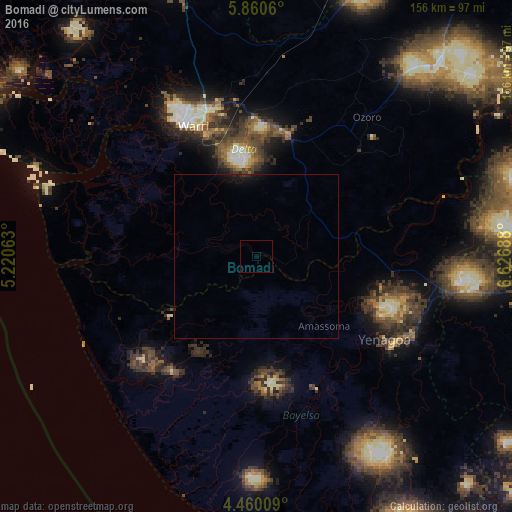
Analysis of Bomadi night lights 2016
Square area 10x10 km:
100  0%
0%
90-99 0%
80-89 0%
70-79 0%
60-69 0%
50-59 0%
40-49 0%
30-39 0%
20-29 0%
10-19 0%
0-9 100%
0%90-99
0%80-89
0%70-79
0%60-69
0%50-59
0%40-49
0%30-39
0%20-29
0%10-19
0%0-9
100%Square area 50x50 km:
100 0%
90-99 0%
80-89 0%
70-79 0%
60-69 0%
50-59 0%
40-49 0%
30-39 0.03%
20-29 0.17%
10-19 0.68%
0-9 99.12%
0%90-99
0%80-89
0%70-79
0%60-69
0%50-59
0%40-49
0%30-39
0.03%20-29
0.17%10-19
0.68%0-9
99.12%Clear (daylight) street map image can be seen on geolist.org.
Map coordinates:
5° 51' 38.2" North, 5° 13' 14.3" East
5° 9' 38.6" North, 5° 55' 25.5" East
4° 27' 36.3" North, 6° 37' 36.8" East
Some cities around Bomadi sort by population:
• Warri
44.1 km =27.4 mi,  334°
334°
• Ughelli
37.6 km =23.4 mi,  13°
13°
• Yenagoa
46.1 km =28.6 mi,  124°
124°
• Burutu
50.7 km =31.5 mi,  294°
294°
• Patani
30.6 km =19 mi,  75°
75°
• Amassoma
29.5 km =18.3 mi,  135°
135°
• Abraka
72.8 km =45.2 mi,  15°
15°
• Orerokpe
53.1 km =33 mi,  355°
355°
2346843 (p: 8,402)
Sources (retrieved 2019-11-25):
» Earth at Night: Flat Maps 2012, 2016