Burutu night lights from space
Night Light of Burutu (Delta) from space (Nigeria) Src. Average luminocity for 10x10km area is 0% and for 50x50km: 3.5676%.
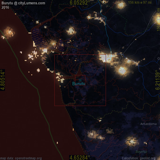
Analysis of Burutu night lights 2016
Square area 10x10 km:
100  0%
0%
90-99 0%
80-89 0%
70-79 0%
60-69 0%
50-59 0%
40-49 0%
30-39 0%
20-29 0%
10-19 0%
0-9 100%
0%90-99
0%80-89
0%70-79
0%60-69
0%50-59
0%40-49
0%30-39
0%20-29
0%10-19
0%0-9
100%Square area 50x50 km:
100 0.52%
90-99 1.41%
80-89 0.32%
70-79 0.18%
60-69 0.06%
50-59 0.09%
40-49 0.3%
30-39 0.61%
20-29 0.65%
10-19 2.7%
0-9 93.15%
0.52%90-99
1.41%80-89
0.32%70-79
0.18%60-69
0.06%50-59
0.09%40-49
0.3%30-39
0.61%20-29
0.65%10-19
2.7%0-9
93.15%Clear (daylight) street map image can be seen on geolist.org.
Map coordinates:
6° 3' 10.5" North, 4° 48' 18.5" East
5° 21' 11.8" North, 5° 30' 29.7" East
4° 39' 10.2" North, 6° 12' 41" East
Some cities around Burutu sort by population:
• Warri
32.4 km =20.1 mi,  55°
55°
• Sapele
62.9 km =39.1 mi,  17°
17°
• Ughelli
56.9 km =35.4 mi,  74°
74°
• Bomadi
50.7 km =31.5 mi,  114°
114°
• Patani
76.9 km =47.8 mi,  100°
100°
• Amassoma
79 km =49.1 mi,  122°
122°
• Abraka
82 km =51 mi,  53°
53°
• Orerokpe
52.8 km =32.8 mi, 53°
2346317 (p: 16,410)
Sources (retrieved 2019-11-25):
» Earth at Night: Flat Maps 2012, 2016