Abraka night lights from space
Night Light of Abraka (Delta) from space (Nigeria) Src. Average luminocity for 10x10km area is 0.2211% and for 50x50km: 6.2777%.
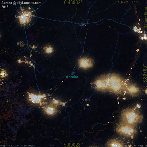
Analysis of Abraka night lights 2016
Square area 10x10 km:
100  0%
0%
90-99 0%
80-89 0%
70-79 0%
60-69 0%
50-59 0%
40-49 0%
30-39 0%
20-29 0%
10-19 0%
0-9 100%
0%90-99
0%80-89
0%70-79
0%60-69
0%50-59
0%40-49
0%30-39
0%20-29
0%10-19
0%0-9
100%Square area 50x50 km:
100 0.18%
90-99 0.9%
80-89 0.65%
70-79 0.62%
60-69 1.11%
50-59 1.1%
40-49 1.41%
30-39 1.92%
20-29 1.77%
10-19 4.57%
0-9 85.77%
0.18%90-99
0.9%80-89
0.65%70-79
0.62%60-69
1.11%50-59
1.1%40-49
1.41%30-39
1.92%20-29
1.77%10-19
4.57%0-9
85.77%Clear (daylight) street map image can be seen on geolist.org.
Map coordinates:
6° 29' 21.6" North, 5° 24' 5.8" East
5° 47' 24.8" North, 6° 6' 17" East
5° 5' 25" North, 6° 48' 28.3" East
Some cities around Abraka sort by population:
• Warri
49.6 km =30.8 mi,  232°
232°
• Sapele
48.7 km =30.3 mi,  283°
283°
• Ughelli
35.2 km =21.9 mi,  198°
198°
• Agbor
52.5 km =32.6 mi,  10°
10°
• Kwale
37.6 km =23.4 mi,  104°
104°
• Obiaruku
8.2 km =5.1 mi,  40°
40°
• Umunede
57.5 km =35.7 mi,  23°
23°
• Orerokpe
29.2 km =18.1 mi, 234°
2352804 (p: 6,940)
Sources (retrieved 2019-11-25):
» Earth at Night: Flat Maps 2012, 2016