Patani night lights from space
Night Light of Patani (Delta) from space (Nigeria) Src. Average luminocity for 10x10km area is 0% and for 50x50km: 3.9035%.
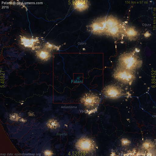
Analysis of Patani night lights 2016
Square area 10x10 km:
100  0%
0%
90-99 0%
80-89 0%
70-79 0%
60-69 0%
50-59 0%
40-49 0%
30-39 0%
20-29 0%
10-19 0%
0-9 100%
0%90-99
0%80-89
0%70-79
0%60-69
0%50-59
0%40-49
0%30-39
0%20-29
0%10-19
0%0-9
100%Square area 50x50 km:
100 0.13%
90-99 0.57%
80-89 0.43%
70-79 0.53%
60-69 0.58%
50-59 0.53%
40-49 0.9%
30-39 1.85%
20-29 0.99%
10-19 1.97%
0-9 91.51%
0.13%90-99
0.57%80-89
0.43%70-79
0.53%60-69
0.58%50-59
0.53%40-49
0.9%30-39
1.85%20-29
0.99%10-19
1.97%0-9
91.51%Clear (daylight) street map image can be seen on geolist.org.
Map coordinates:
5° 55' 43.1" North, 5° 29' 17.8" East
5° 13' 43.9" North, 6° 11' 29" East
4° 31' 41.8" North, 6° 53' 40.3" East
Some cities around Patani sort by population:
• Warri
58.4 km =36.3 mi,  303°
303°
• Ughelli
35.6 km =22.1 mi,  324°
324°
• Yenagoa
34.6 km =21.5 mi,  165°
165°
• Ahoada
53.3 km =33.1 mi,  107°
107°
• Omoku
53.1 km =33 mi,  76°
76°
• Bomadi
30.6 km =19 mi,  255°
255°
• Amassoma
30.2 km =18.8 mi,  197°
197°
• Orerokpe
56.4 km =35 mi, 323°
2324962 (p: 7,327)
Sources (retrieved 2019-11-25):
» Earth at Night: Flat Maps 2012, 2016