Amassoma night lights from space
Night Light of Amassoma (Bayelsa) from space (Nigeria) Src. Average luminocity for 10x10km area is 0% and for 50x50km: 6.9947%.
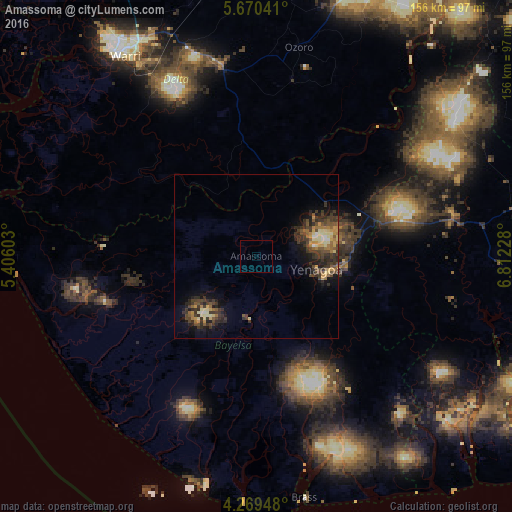
Analysis of Amassoma night lights 2016
Square area 10x10 km:
 0%
0%90-99
0%80-89
0%70-79
0%60-69
0%50-59
0%40-49
0%30-39
0%20-29
0%10-19
0%0-9
100%Square area 50x50 km:
0.16%90-99
0.89%80-89
0.87%70-79
0.93%60-69
1.07%50-59
0.97%40-49
1.67%30-39
3.12%20-29
2.21%10-19
3.41%0-9
84.69%Clear (daylight) street map image can be seen on geolist.org.
Map coordinates:
5° 40' 13.5" North, 5° 24' 21.7" East
4° 58' 13.2" North, 6° 6' 32.9" East
4° 16' 10.1" North, 6° 48' 44.2" East
Some cities around Amassoma sort by population:
• Warri
72.7 km =45.2 mi,  326°
326°
• Ughelli
58.9 km =36.6 mi,  348°
348°
• Yenagoa
18.2 km =11.3 mi,  105°
105°
• Ahoada
61.2 km =38 mi,  78°
78°
• Omoku
73.5 km =45.7 mi,  55°
55°
• Twon-Brass
74.6 km =46.4 mi,  168°
168°
• Bomadi
29.5 km =18.3 mi,  315°
315°
• Patani
30.2 km =18.8 mi,  17°
17°
2350172 (p: 6,970)
Sources (retrieved 2019-11-25):
» Earth at Night: Flat Maps 2012, 2016