Bokani night lights from space
Night Light of Bokani (Niger) from space (Nigeria) Src. Average luminocity for 10x10km area is 0% and for 50x50km: 0.2998%.
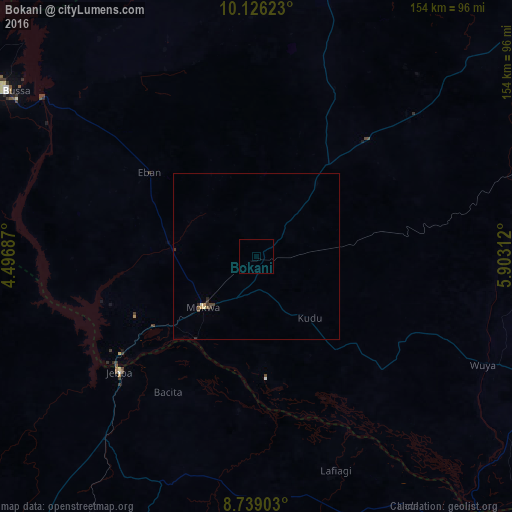
Analysis of Bokani night lights 2016
Square area 10x10 km:
100  0%
0%
90-99 0%
80-89 0%
70-79 0%
60-69 0%
50-59 0%
40-49 0%
30-39 0%
20-29 0%
10-19 0%
0-9 100%
0%90-99
0%80-89
0%70-79
0%60-69
0%50-59
0%40-49
0%30-39
0%20-29
0%10-19
0%0-9
100%Square area 50x50 km:
100 0%
90-99 0.01%
80-89 0.06%
70-79 0.05%
60-69 0.02%
50-59 0.07%
40-49 0.1%
30-39 0.09%
20-29 0.13%
10-19 0%
0-9 99.47%
0%90-99
0.01%80-89
0.06%70-79
0.05%60-69
0.02%50-59
0.07%40-49
0.1%30-39
0.09%20-29
0.13%10-19
0%0-9
99.47%Clear (daylight) street map image can be seen on geolist.org.
Map coordinates:
10° 7' 34.4" North, 4° 29' 48.7" East
9° 25' 60" North, 5° 12' 0" East
8° 44' 20.5" North, 5° 54' 11.2" East
Some cities around Bokani sort by population:
• Bida
97.2 km =60.4 mi,  113°
113°
• Lafiagi
68.8 km =42.8 mi,  159°
159°
• Patigi
99.3 km =61.7 mi,  142°
142°
• Jebba
54.1 km =33.6 mi,  229°
229°
• Mokwa
22.2 km =13.8 mi, 226°
• Bode Saadu
71.6 km =44.5 mi,  219°
219°
• Wawa
100.2 km =62.3 mi,  301°
301°
• Auna
98.8 km =61.4 mi,  328°
328°
2346893 (p: 8,624)
Sources (retrieved 2019-11-25):
» Earth at Night: Flat Maps 2012, 2016