Ahoada night lights from space
Night Light of Ahoada (Rivers) from space (Nigeria) Src. Average luminocity for 10x10km area is 20.2686% and for 50x50km: 14.8279%.
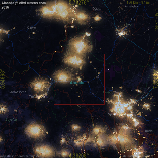
Analysis of Ahoada night lights 2016
Square area 10x10 km:
 0%
0%90-99
0%80-89
0.21%70-79
3.1%60-69
2.48%50-59
3.51%40-49
6.82%30-39
11.78%20-29
7.64%10-19
23.76%0-9
40.7%Square area 50x50 km:
0.99%90-99
1.67%80-89
1.89%70-79
1.63%60-69
1.88%50-59
3.69%40-49
4.34%30-39
4.65%20-29
4.38%10-19
7.34%0-9
67.55%Clear (daylight) street map image can be seen on geolist.org.
Map coordinates:
5° 46' 57.9" North, 5° 56' 48" East
5° 4' 58.1" North, 6° 38' 59.3" East
4° 22' 55.5" North, 7° 21' 10.5" East
Some cities around Ahoada sort by population:
• Port Harcourt
52.7 km =32.7 mi,  130°
130°
• Buguma
45.2 km =28.1 mi,  148°
148°
• Obonoma
44.2 km =27.5 mi,  159°
159°
• Yenagoa
45.7 km =28.4 mi,  247°
247°
• Elele
18.3 km =11.4 mi,  83°
83°
• Degema Hulk
37.4 km =23.2 mi, 162°
• Omoku
29 km =18 mi,  1°
1°
• Patani
53.3 km =33.1 mi,  287°
287°
2351657 (p: 12,848)
Sources (retrieved 2019-11-25):
» Earth at Night: Flat Maps 2012, 2016