Amagunze night lights from space
Night Light of Amagunze (Enugu) from space (Nigeria) Src. Average luminocity for 10x10km area is 0% and for 50x50km: 5.3601%.
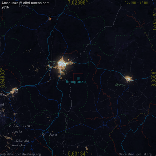
Analysis of Amagunze night lights 2016
Square area 10x10 km:
100  0%
0%
90-99 0%
80-89 0%
70-79 0%
60-69 0%
50-59 0%
40-49 0%
30-39 0%
20-29 0%
10-19 0%
0-9 100%
0%90-99
0%80-89
0%70-79
0%60-69
0%50-59
0%40-49
0%30-39
0%20-29
0%10-19
0%0-9
100%Square area 50x50 km:
100 0.5%
90-99 0.8%
80-89 0.52%
70-79 0.76%
60-69 0.99%
50-59 0.76%
40-49 0.95%
30-39 1%
20-29 1.66%
10-19 3.76%
0-9 88.29%
0.5%90-99
0.8%80-89
0.52%70-79
0.76%60-69
0.99%50-59
0.76%40-49
0.95%30-39
1%20-29
1.66%10-19
3.76%0-9
88.29%Clear (daylight) street map image can be seen on geolist.org.
Map coordinates:
7° 1' 44.3" North, 6° 56' 57.7" East
6° 19' 50.3" North, 7° 39' 8.9" East
5° 37' 52.8" North, 8° 21' 20.2" East
Some cities around Amagunze sort by population:
• Enugu
21 km =13 mi,  305°
305°
• Isieke
42.9 km =26.7 mi,  82°
82°
• Eha Amufu
38.4 km =23.9 mi,  17°
17°
• Ezza-Ohu
49.3 km =30.6 mi, 75°
• Awgu
34.6 km =21.5 mi,  214°
214°
• Udi
25.6 km =15.9 mi,  266°
266°
• Mberubu
17.7 km =11 mi,  188°
188°
• Ake-Eze
46.1 km =28.6 mi,  176°
176°
2350259 (p: 9,598)
Sources (retrieved 2019-11-25):
» Earth at Night: Flat Maps 2012, 2016