Parit Raja night lights from space
Night Light of Parit Raja (Johor) from space (Malaysia) Src. Average luminocity for 10x10km area is 39.6667% and for 50x50km: 18.9373%.
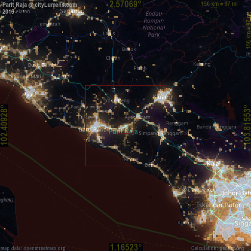
Analysis of Parit Raja night lights 2016
Square area 10x10 km:
 3.68%
3.68%90-99
3.9%80-89
1.95%70-79
6.71%60-69
8.01%50-59
13.64%40-49
8.66%30-39
3.9%20-29
9.74%10-19
35.71%0-9
4.11%Square area 50x50 km:
1.73%90-99
2.35%80-89
1.1%70-79
3.04%60-69
2.47%50-59
3%40-49
4.17%30-39
3.21%20-29
5.69%10-19
16.87%0-9
56.36%Clear (daylight) street map image can be seen on geolist.org.
Map coordinates:
2° 34' 14.5" North, 102° 24' 33.4" East
1° 52' 5.2" North, 103° 6' 44.6" East
1° 9' 54.8" North, 103° 48' 55.9" East
Some cities around Parit Raja sort by population:
• Kluang
29 km =18 mi,  51°
51°
• Batu Pahat
20 km =12.4 mi,  265°
265°
• Pontian Kechil
52.4 km =32.6 mi,  144°
144°
• Bakri
54.7 km =34 mi,  290°
290°
• Yong Peng
17 km =10.6 mi,  342°
342°
• Kampung Simpang Renggam
21.3 km =13.2 mi,  102°
102°
• Kelapa Sawit
51.7 km =32.1 mi,  115°
115°
• Chaah
43 km =26.7 mi,  350°
350°
1732698 (p: 17,441)
Sources (retrieved 2019-11-25):
» Earth at Night: Flat Maps 2012, 2016