Chaah night lights from space
Night Light of Chaah (Johor) from space (Malaysia) Src. Average luminocity for 10x10km area is 4.1645% and for 50x50km: 2.5935%.
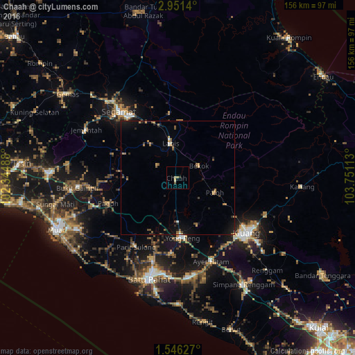
Analysis of Chaah night lights 2016
Square area 10x10 km:
 0%
0%90-99
0.65%80-89
1.52%70-79
0.43%60-69
0.87%50-59
0%40-49
0.87%30-39
0.87%20-29
0%10-19
0.87%0-9
93.94%Square area 50x50 km:
0.06%90-99
0.16%80-89
0.11%70-79
0.69%60-69
0.38%50-59
0.47%40-49
0.35%30-39
0.35%20-29
0.61%10-19
1.77%0-9
95.05%Clear (daylight) street map image can be seen on geolist.org.
Map coordinates:
2° 57' 5" North, 102° 20' 41.6" East
2° 14' 56.4" North, 103° 2' 52.8" East
1° 32' 46.6" North, 103° 45' 4.1" East
Some cities around Chaah sort by population:
• Kluang
38.5 km =23.9 mi,  129°
129°
• Batu Pahat
45.7 km =28.4 mi,  196°
196°
• Segamat
39.2 km =24.4 mi,  318°
318°
• Bakri
49.5 km =30.8 mi,  242°
242°
• Yong Peng
26.2 km =16.3 mi,  175°
175°
• Labis
15.4 km =9.6 mi,  348°
348°
• Parit Raja
43 km =26.7 mi,  170°
170°
• Buloh Kasap
46.3 km =28.8 mi, 317°
1732884 (p: 11,844)
Sources (retrieved 2019-11-25):
» Earth at Night: Flat Maps 2012, 2016