Oriental night lights from space
Night Light of Oriental (Puebla) from space (Mexico) Src. Average luminocity for 10x10km area is 10.9483% and for 50x50km: 6.3724%.
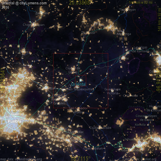
Analysis of Oriental night lights 2016
Square area 10x10 km:
 1.03%
1.03%90-99
0.62%80-89
1.65%70-79
0%60-69
1.45%50-59
3.51%40-49
2.48%30-39
1.03%20-29
1.45%10-19
0.83%0-9
85.95%Square area 50x50 km:
0.11%90-99
0.27%80-89
0.94%70-79
0.72%60-69
0.91%50-59
0.96%40-49
1.82%30-39
1.47%20-29
1.31%10-19
3.78%0-9
87.72%Clear (daylight) street map image can be seen on geolist.org.
Map coordinates:
20° 2' 17.1" North, 98° 19' 25.1" West
19° 22' 34.1" North, 97° 37' 13.8" West
18° 42' 41.4" North, 96° 55' 2.6" West
Some cities around Oriental sort by population:
• San Salvador El Seco
27.1 km =16.8 mi,  184°
184°
• Libres
12.2 km =7.6 mi,  324°
324°
• Villa de El Carmen Tequexquitla
6.7 km =4.2 mi,  210°
210°
• Zacatepec
15.3 km =9.5 mi,  142°
142°
• Grajales
25.3 km =15.7 mi,  229°
229°
• Cuapiaxtla
17.9 km =11.1 mi,  240°
240°
• Nopalucán
27.5 km =17.1 mi, 230°
• San José Xicohténcatl
22.2 km =13.8 mi,  263°
263°
3522317 (p: 9,957)
Sources (retrieved 2019-11-25):
» Earth at Night: Flat Maps 2012, 2016