Zacapechpan night lights from space
Night Light of Zacapechpan (Puebla) from space (Mexico) Src. Average luminocity for 10x10km area is 69.4156% and for 50x50km: 49.7173%.
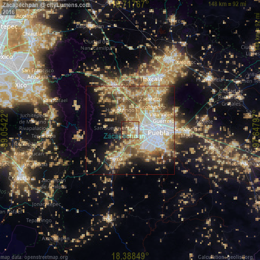
Analysis of Zacapechpan night lights 2016
Square area 10x10 km:
 8.66%
8.66%90-99
12.77%80-89
18.18%70-79
17.1%60-69
10.17%50-59
7.79%40-49
11.04%30-39
9.74%20-29
4.55%10-19
0%0-9
0%Square area 50x50 km:
9.25%90-99
7.03%80-89
12.4%70-79
8.49%60-69
7.14%50-59
6.85%40-49
7.08%30-39
5.04%20-29
5.97%10-19
10%0-9
20.75%Clear (daylight) street map image can be seen on geolist.org.
Map coordinates:
19° 43' 3.6" North, 99° 3' 15.2" West
19° 3' 15.9" North, 98° 21' 3.9" West
18° 23' 18.6" North, 97° 38' 52.7" West
Some cities around Zacapechpan sort by population:
• Cholula
5.1 km =3.2 mi,  77°
77°
• San Bernardino Tlaxcalancingo
8.3 km =5.2 mi,  110°
110°
• San Andrés Cholula
5.9 km =3.7 mi,  93°
93°
• Cuautlancingo
9.1 km =5.7 mi,  64°
64°
• Coronango
8.8 km =5.5 mi,  32°
32°
• Santa María Zacatepec
7.8 km =4.8 mi,  348°
348°
• Nealtican
8 km =5 mi,  266°
266°
• Cuanalá
6.6 km =4.1 mi,  21°
21°
9870991 (p: 6,959)
Sources (retrieved 2019-11-25):
» Earth at Night: Flat Maps 2012, 2016