Nealtican night lights from space
Night Light of Nealtican (Puebla) from space (Mexico) Src. Average luminocity for 10x10km area is 24.9307% and for 50x50km: 41.746%.
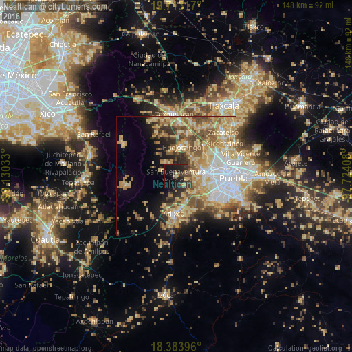
Analysis of Nealtican night lights 2016
Square area 10x10 km:
 0%
0%90-99
0%80-89
5.41%70-79
1.73%60-69
2.38%50-59
3.25%40-49
5.41%30-39
9.09%20-29
16.02%10-19
38.31%0-9
18.4%Square area 50x50 km:
7.19%90-99
4.97%80-89
10.59%70-79
8.08%60-69
6.52%50-59
5.84%40-49
5.7%30-39
3.89%20-29
4.8%10-19
9.21%0-9
33.22%Clear (daylight) street map image can be seen on geolist.org.
Map coordinates:
19° 42' 47.4" North, 99° 7' 49.2" West
19° 2' 59.6" North, 98° 25' 37.9" West
18° 23' 2.3" North, 97° 43' 26.7" West
Some cities around Nealtican sort by population:
• Huejotzingo
12.3 km =7.6 mi,  9°
9°
• Santa María Zacatepec
10.4 km =6.5 mi,  38°
38°
• San Andrés Calpan
7 km =4.3 mi,  328°
328°
• Zacapechpan
8 km =5 mi,  86°
86°
• Domingo Arenas
10.5 km =6.5 mi,  342°
342°
• Cuanalá
12.3 km =7.6 mi,  57°
57°
• San Nicolás de los Ranchos
6.6 km =4.1 mi,  291°
291°
• Tianguismanalco
8.5 km =5.3 mi,  195°
195°
3522781 (p: 11,517)
Sources (retrieved 2019-11-25):
» Earth at Night: Flat Maps 2012, 2016