Santa María Zacatepec night lights from space
Night Light of Santa María Zacatepec (Puebla) from space (Mexico) Src. Average luminocity for 10x10km area is 60.1299% and for 50x50km: 54.6837%.
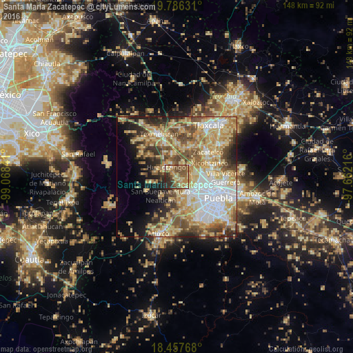
Analysis of Santa María Zacatepec night lights 2016
Square area 10x10 km:
 1.52%
1.52%90-99
3.46%80-89
16.88%70-79
14.29%60-69
12.55%50-59
21.65%40-49
10.82%30-39
8.87%20-29
9.74%10-19
0.22%0-9
0%Square area 50x50 km:
9.95%90-99
8%80-89
14.52%70-79
9.89%60-69
8.08%50-59
7.39%40-49
7.72%30-39
4.97%20-29
5.92%10-19
6.61%0-9
16.95%Clear (daylight) street map image can be seen on geolist.org.
Map coordinates:
19° 47' 10.7" North, 99° 4' 6.3" West
19° 7' 24" North, 98° 21' 55" West
18° 27' 27.6" North, 97° 39' 43.8" West
Some cities around Santa María Zacatepec sort by population:
• Huejotzingo
6 km =3.7 mi,  311°
311°
• Coronango
6.2 km =3.9 mi,  92°
92°
• San Francisco Ocotlán
8.7 km =5.4 mi,  82°
82°
• San Miguel Xoxtla
7.8 km =4.8 mi,  50°
50°
• Zacapechpan
7.8 km =4.8 mi,  168°
168°
• San Antonio Mihuacán
7.2 km =4.5 mi,  62°
62°
• Tlaltenango
6 km =3.7 mi,  25°
25°
• Cuanalá
4.2 km =2.6 mi,  111°
111°
8858137 (p: 12,466)
Sources (retrieved 2019-11-25):
» Earth at Night: Flat Maps 2012, 2016