Xochimanca night lights from space
Night Light of Xochimanca (México) from space (Mexico) Src. Average luminocity for 10x10km area is 69.7624% and for 50x50km: 52.938%.
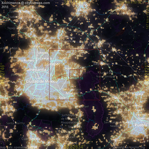
Analysis of Xochimanca night lights 2016
Square area 10x10 km:
 5.58%
5.58%90-99
11.16%80-89
18.39%70-79
19.63%60-69
14.46%50-59
16.53%40-49
5.79%30-39
3.31%20-29
3.31%10-19
1.86%0-9
0%Square area 50x50 km:
16.63%90-99
10.21%80-89
10.35%70-79
9.43%60-69
6.38%50-59
3.76%40-49
3.27%30-39
2.27%20-29
3%10-19
5.73%0-9
28.98%Clear (daylight) street map image can be seen on geolist.org.
Map coordinates:
20° 9' 7.1" North, 99° 31' 38.9" West
19° 29' 25.9" North, 98° 49' 27.6" West
18° 49' 34.8" North, 98° 7' 16.4" West
Some cities around Xochimanca sort by population:
• Texcoco de Mora
6.6 km =4.1 mi,  291°
291°
• San Miguel Coatlinchán
6.8 km =4.2 mi,  228°
228°
• Tulantongo
7 km =4.3 mi,  310°
310°
• San Miguel Tlaixpan
2.5 km =1.6 mi,  33°
33°
• San Joaquín Coapango
5.6 km =3.5 mi,  356°
356°
• Santa Catarina del Monte
5.5 km =3.4 mi,  97°
97°
• Tequexquináhuac
1.4 km =0.9 mi,  182°
182°
• Xocotlán
3.7 km =2.3 mi,  321°
321°
3519487 (p: 5,239)
Sources (retrieved 2019-11-25):
» Earth at Night: Flat Maps 2012, 2016