Tulantongo night lights from space
Night Light of Tulantongo (México) from space (Mexico) Src. Average luminocity for 10x10km area is 89.2893% and for 50x50km: 61.3618%.
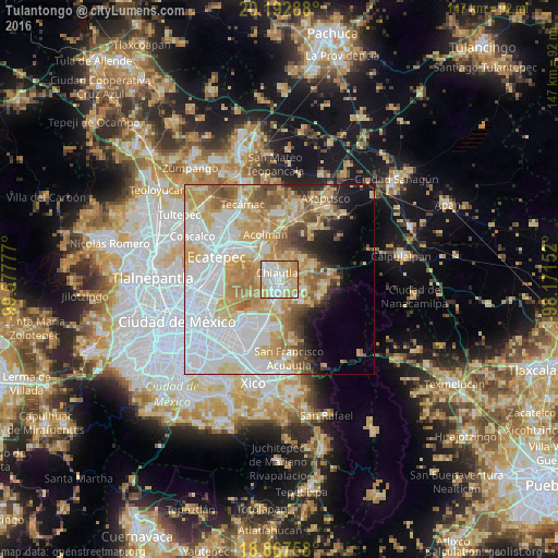
Analysis of Tulantongo night lights 2016
Square area 10x10 km:
 26.03%
90-99
26.65%80-89
22.93%70-79
22.31%60-69
2.07%50-59
0%40-49
0%30-39
0%20-29
0%10-19
0%0-9
0%Square area 50x50 km:
21.6%90-99
10.46%80-89
11.38%70-79
10.58%60-69
7.51%50-59
4.88%40-49
3.93%30-39
2.27%20-29
3.65%10-19
5.21%0-9
18.53%Clear (daylight) street map image can be seen on geolist.org.
Map coordinates:
20° 11' 34.4" North, 99° 34' 40" West
19° 31' 53.7" North, 98° 52' 28.7" West
18° 52' 3.3" North, 98° 10' 17.5" West
Some cities around Tulantongo sort by population:
• Texcoco de Mora
2.4 km =1.5 mi,  201°
201°
• Chiconcuac
4 km =2.5 mi,  320°
320°
• San Salvador Atenco
5.1 km =3.2 mi,  295°
295°
• Chiautla
2.1 km =1.3 mi,  337°
337°
• San Joaquín Coapango
5 km =3.1 mi,  78°
78°
• Concepción Jolalpan
6.5 km =4 mi,  26°
26°
• La Pastoría
4 km =2.5 mi,  288°
288°
• Xocotlán
3.4 km =2.1 mi,  119°
119°
3817714 (p: 15,584)
Sources (retrieved 2019-11-25):
» Earth at Night: Flat Maps 2012, 2016