San Joaquín Coapango night lights from space
Night Light of San Joaquín Coapango (México) from space (Mexico) Src. Average luminocity for 10x10km area is 78.1178% and for 50x50km: 52.4653%.
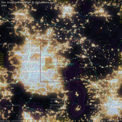
Analysis of San Joaquín Coapango night lights 2016
Square area 10x10 km:
 5.17%
5.17%90-99
11.16%80-89
32.23%70-79
27.48%60-69
13.02%50-59
9.71%40-49
0.83%30-39
0.41%20-29
0%10-19
0%0-9
0%Square area 50x50 km:
14.55%90-99
8.85%80-89
10.09%70-79
9.93%60-69
7.94%50-59
5.19%40-49
4.29%30-39
2.57%20-29
4.25%10-19
7.01%0-9
25.33%Clear (daylight) street map image can be seen on geolist.org.
Map coordinates:
20° 12' 6.1" North, 99° 31' 49.9" West
19° 32' 25.5" North, 98° 49' 38.6" West
18° 52' 35.2" North, 98° 7' 27.4" West
Some cities around San Joaquín Coapango sort by population:
• Texcoco de Mora
6.6 km =4.1 mi,  241°
241°
• Tulantongo
5 km =3.1 mi,  258°
258°
• Chiautla
5.8 km =3.6 mi,  279°
279°
• San Miguel Tlaixpan
3.8 km =2.4 mi,  153°
153°
• Tepetlaoxtoc de Hidalgo
3.9 km =2.4 mi,  14°
14°
• Concepción Jolalpan
5.2 km =3.2 mi,  337°
337°
• Xochimanca
5.6 km =3.5 mi,  176°
176°
• Xocotlán
3.3 km =2.1 mi,  216°
216°
3519032 (p: 6,774)
Sources (retrieved 2019-11-25):
» Earth at Night: Flat Maps 2012, 2016