San Miguel Tlaixpan night lights from space
Night Light of San Miguel Tlaixpan (México) from space (Mexico) Src. Average luminocity for 10x10km area is 72.6983% and for 50x50km: 50.3129%.
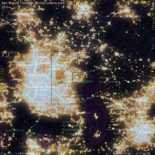
Analysis of San Miguel Tlaixpan night lights 2016
Square area 10x10 km:
 2.48%
2.48%90-99
10.33%80-89
24.17%70-79
22.11%60-69
16.94%50-59
18.39%40-49
2.89%30-39
2.07%20-29
0.62%10-19
0%0-9
0%Square area 50x50 km:
13.78%90-99
9.15%80-89
10.04%70-79
9.3%60-69
7.16%50-59
4.65%40-49
3.78%30-39
2.51%20-29
3.3%10-19
7.18%0-9
29.15%Clear (daylight) street map image can be seen on geolist.org.
Map coordinates:
20° 10' 15.5" North, 99° 30' 50.3" West
19° 30' 34.5" North, 98° 48' 39" West
18° 50' 43.7" North, 98° 6' 27.8" West
Some cities around San Miguel Tlaixpan sort by population:
• Tulantongo
7.1 km =4.4 mi,  290°
290°
• San Joaquín Coapango
3.8 km =2.4 mi,  333°
333°
• San Jerónimo Amanalco
5.7 km =3.5 mi,  80°
80°
• Tepetlaoxtoc de Hidalgo
7.2 km =4.5 mi,  353°
353°
• Santa Catarina del Monte
4.9 km =3 mi,  125°
125°
• Tequexquináhuac
3.9 km =2.4 mi,  202°
202°
• Xochimanca
2.5 km =1.6 mi,  213°
213°
• Xocotlán
3.8 km =2.4 mi,  281°
281°
3817702 (p: 7,064)
Sources (retrieved 2019-11-25):
» Earth at Night: Flat Maps 2012, 2016